
Make a donation
Gear up for your next adventure:
As an Amazon Associate, this site earns from qualifying purchases at no extra cost to you.
Kilkare Woods topographic map
Click on the map to display elevation.
Make a donation
Gear up for your next adventure:
As an Amazon Associate, this site earns from qualifying purchases at no extra cost to you.
About this map
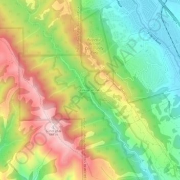
Name: Kilkare Woods topographic map, elevation, terrain.
Location: Kilkare Woods, Alameda County, California, United States (37.60827 -121.93218 37.64827 -121.89218)
Average elevation: 339 m
Minimum elevation: 84 m
Maximum elevation: 664 m
Make a donation
Gear up for your next adventure:
As an Amazon Associate, this site earns from qualifying purchases at no extra cost to you.
Other topographic maps
Click on a map to view its topography, its elevation and its terrain.
Oakland
United States > California > Alameda County
Oakland features a diverse topography shaped by its location along the eastern shore of San Francisco Bay and the presence of the nearby coastal hills. The city sits on a flat coastal plain that gradually ascends toward the Oakland Hills to the east, where elevations can exceed 1,700 feet. The highest point…
Average elevation: 51 m
Berkeley
United States > California > Alameda County
Berkeley, located on the eastern shore of San Francisco Bay, features a diverse topography characterized by rolling hills and steep slopes. The city sits at an elevation that ranges from sea level along the bay to about 1,300 feet (396 meters) in the Berkeley Hills. This hilly landscape provides stunning views…
Average elevation: 109 m
Berkeley
United States > California > Alameda County
In 1866, Oakland's private College of California looked for a new site. It settled on a location north of Oakland along the foot of the Contra Costa Range (later called the Berkeley Hills) on Strawberry Creek, at an elevation of about 500 feet (150 m) above the bay, commanding a view of the Bay Area and the…
Average elevation: 109 m
Make a donation
Gear up for your next adventure:
As an Amazon Associate, this site earns from qualifying purchases at no extra cost to you.
Fremont
United States > California > Alameda County
Centerville was the main town in Washington Township. Centerville is located at 37°33′15″N 121°59′57″W / 37.55417°N 121.99917°W / 37.55417; -121.99917 (Centerville). It lies at an elevation of 52 feet (16 m). Centerville was started by George Lloyd who started selling cold beer to stage…
Average elevation: 93 m
Make a donation
Gear up for your next adventure:
As an Amazon Associate, this site earns from qualifying purchases at no extra cost to you.
San Leandro
United States > California > Alameda County
The San Leandro Hills run above the city to the northeast. In the lower elevations of the city, an upper regionally contained aquifer is located 50 to 100 feet (15 to 30 m) below the surface. At least one deeper aquifer exists approximately 250 feet (75 m) below the surface. Some salt water intrusion has taken…
Average elevation: 21 m
Make a donation
Gear up for your next adventure:
As an Amazon Associate, this site earns from qualifying purchases at no extra cost to you.
Fairview
United States > California > Alameda County > Fairview
The terrain is hilly to gently rolling, with elevations ranging from 200 feet near the Don Castro Regional Recreation Area (a park within the East Bay Regional Park District) to nearly 1,100 feet along Fairview Avenue.
Average elevation: 123 m
Berkeley Hills
United States > California > Alameda County > Berkeley
The Berkeley Hills are bounded by the major Hayward Fault along their western base, and the minor Wildcat fault on their eastern side. The highest peaks are Grizzly Peak with an elevation of 1,754 feet (535 m) and Round Top, an extinct volcano with an elevation of 1,761 feet (537 m) and William Rust Summit at…
Average elevation: 158 m
Make a donation
Gear up for your next adventure:
As an Amazon Associate, this site earns from qualifying purchases at no extra cost to you.
Berkeley Hills
United States > California > Alameda County > Berkeley
The Berkeley Hills are bounded by the major Hayward Fault along their western base, and the minor Wildcat fault on their eastern side. The highest peaks are Grizzly Peak with an elevation of 1,754 feet (535 m) and Round Top, an extinct volcano with an elevation of 1,761 feet (537 m) and William Rust Summit at…
Average elevation: 158 m
Oakland
United States > California > Alameda County
Oakland, like much of Northern California, is susceptible to winter rainstorms and Atmospheric rivers. The wettest "rain year" was from July 1997 to June 1998 with 47.76 inches (1,213.1 mm) and the driest from July 2020 to June 2021 with 8.03 inches (204.0 mm). The most rainfall in one month was 15.35 inches…
Average elevation: 51 m
Make a donation
Gear up for your next adventure:
As an Amazon Associate, this site earns from qualifying purchases at no extra cost to you.
Make a donation
Gear up for your next adventure:
As an Amazon Associate, this site earns from qualifying purchases at no extra cost to you.
Fremont
United States > California > Alameda County
Centerville was the main town in Washington Township. Centerville is located at 37°33′15″N 121°59′57″W / 37.55417°N 121.99917°W / 37.55417; -121.99917 (Centerville). It lies at an elevation of 52 feet (16 m). Centerville was started by George Lloyd who started selling cold beer to stage…
Average elevation: 93 m
Berkeley
United States > California > Alameda County
In 1866, Oakland's private College of California looked for a new site. It settled on a location north of Oakland along the foot of the Contra Costa Range (later called the Berkeley Hills) on Strawberry Creek, at an elevation of about 500 feet (150 m) above the bay, commanding a view of the Bay Area and the…
Average elevation: 109 m
Make a donation
Gear up for your next adventure:
As an Amazon Associate, this site earns from qualifying purchases at no extra cost to you.
Contra Costa Rock Park
United States > California > Alameda County > Berkeley
Average elevation: 113 m
Oakland
United States > California > Alameda County
Oakland, like much of Northern California, is susceptible to winter rainstorms and Atmospheric rivers. The wettest "rain year" was from July 1997 to June 1998 with 47.76 inches (1,213.1 mm) and the driest from July 2020 to June 2021 with 8.03 inches (204.0 mm). The most rainfall in one month was 15.35 inches…
Average elevation: 51 m
Make a donation
Gear up for your next adventure:
As an Amazon Associate, this site earns from qualifying purchases at no extra cost to you.
Berkeley
United States > California > Alameda County
In 1866, Oakland's private College of California looked for a new site. It settled on a location north of Oakland along the foot of the Contra Costa Range (later called the Berkeley Hills) on Strawberry Creek, at an elevation of about 500 feet (150 m) above the bay, commanding a view of the Bay Area and the…
Average elevation: 109 m
Make a donation
Gear up for your next adventure:
As an Amazon Associate, this site earns from qualifying purchases at no extra cost to you.
Make a donation
Gear up for your next adventure:
As an Amazon Associate, this site earns from qualifying purchases at no extra cost to you.
Coyote Hills Regional Park
United States > California > Alameda County > Fremont
Average elevation: 5 m
Berkeley
United States > California > Alameda County
In 1866, Oakland's private College of California looked for a new site. It settled on a location north of Oakland along the foot of the Contra Costa Range (later called the Berkeley Hills) on Strawberry Creek, at an elevation of about 500 feet (150 m) above the bay, commanding a view of the Bay Area and the…
Average elevation: 109 m
Make a donation
Gear up for your next adventure:
As an Amazon Associate, this site earns from qualifying purchases at no extra cost to you.
Make a donation
Gear up for your next adventure:
As an Amazon Associate, this site earns from qualifying purchases at no extra cost to you.
Make a donation
Gear up for your next adventure:
As an Amazon Associate, this site earns from qualifying purchases at no extra cost to you.
Berkeley
United States > California > Alameda County
In 1866, Oakland's private College of California looked for a new site. It settled on a location north of Oakland along the foot of the Contra Costa Range (later called the Berkeley Hills) on Strawberry Creek, at an elevation of about 500 feet (150 m) above the bay, commanding a view of the Bay Area and the…
Average elevation: 109 m
Make a donation
Gear up for your next adventure:
As an Amazon Associate, this site earns from qualifying purchases at no extra cost to you.
Berkeley
United States > California > Alameda County
In 1866, Oakland's private College of California looked for a new site. It settled on a location north of Oakland along the foot of the Contra Costa Range (later called the Berkeley Hills) astride Strawberry Creek, at an elevation of about 500 feet (150 m) above the bay, commanding a view of the Bay Area and…
Average elevation: 109 m
Make a donation
Gear up for your next adventure:
As an Amazon Associate, this site earns from qualifying purchases at no extra cost to you.
San Leandro
United States > California > Alameda County
The San Leandro Hills run above the city to the northeast. In the lower elevations of the city, an upper regionally contained aquifer is located 50 to 100 feet (15 to 30 m) below the surface. At least one deeper aquifer exists approximately 250 feet (75 m) below the surface. Some salt water intrusion has taken…
Average elevation: 21 m
Make a donation
Gear up for your next adventure:
As an Amazon Associate, this site earns from qualifying purchases at no extra cost to you.
Mission Peak Regional Preserve
United States > California > Alameda County > Fremont
Average elevation: 322 m
Make a donation
Gear up for your next adventure:
As an Amazon Associate, this site earns from qualifying purchases at no extra cost to you.
San Leandro
United States > California > Alameda County
The San Leandro Hills run above the city to the northeast. In the lower elevations of the city, an upper regionally contained aquifer is located 50 to 100 feet (15 to 30 m) below the surface. At least one deeper aquifer exists approximately 250 feet (75 m) below the surface. Some salt water intrusion has taken…
Average elevation: 21 m