
Make a donation
Gear up for your next adventure:
As an Amazon Associate, this site earns from qualifying purchases at no extra cost to you.
Oakland topographic map
Click on the map to display elevation.
Make a donation
Gear up for your next adventure:
As an Amazon Associate, this site earns from qualifying purchases at no extra cost to you.
Oakland
Oakland, like much of Northern California, is susceptible to winter rainstorms and Atmospheric rivers. The wettest "rain year" was from July 1997 to June 1998 with 47.76 inches (1,213.1 mm) and the driest from July 2020 to June 2021 with 8.03 inches (204.0 mm). The most rainfall in one month was 15.35 inches (390 mm) in January 1911. The most rainfall in 24 hours was 4.75 inches (121 mm) on December 31, 2022. Rainfall near the bayfront is only 23 inches (580 mm), but is higher in the Oakland Hills to the east (up to 30 inches [760 mm]), with nearly all precipitation falling between November and April. While measurable amounts of snowfall in Oakland at sea level is very rare, light snow accumulates on the ground the higher elevations of the Oakland hills with more regularity.
Make a donation
Gear up for your next adventure:
As an Amazon Associate, this site earns from qualifying purchases at no extra cost to you.
About this map
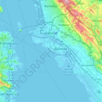
Name: Oakland topographic map, elevation, terrain.
Location: Oakland, Alameda County, California, United States (37.63368 -122.35588 37.88543 -122.11442)
Average elevation: 51 m
Minimum elevation: -11 m
Maximum elevation: 569 m
Make a donation
Gear up for your next adventure:
As an Amazon Associate, this site earns from qualifying purchases at no extra cost to you.
Other topographic maps
Click on a map to view its topography, its elevation and its terrain.
Berkeley Hills
United States > California > Alameda County > Berkeley
The Berkeley Hills are bounded by the major Hayward Fault along their western base, and the minor Wildcat fault on their eastern side. The highest peaks are Grizzly Peak with an elevation of 1,754 feet (535 m) and Round Top, an extinct volcano with an elevation of 1,761 feet (537 m) and William Rust Summit at…
Average elevation: 158 m
Make a donation
Gear up for your next adventure:
As an Amazon Associate, this site earns from qualifying purchases at no extra cost to you.
Contra Costa Rock Park
United States > California > Alameda County > Berkeley
Average elevation: 113 m
Make a donation
Gear up for your next adventure:
As an Amazon Associate, this site earns from qualifying purchases at no extra cost to you.
Coyote Hills Regional Park
United States > California > Alameda County > Fremont
Average elevation: 5 m
Make a donation
Gear up for your next adventure:
As an Amazon Associate, this site earns from qualifying purchases at no extra cost to you.