
Medina County topographic map
Interactive map
Click on the map to display elevation.
About this map
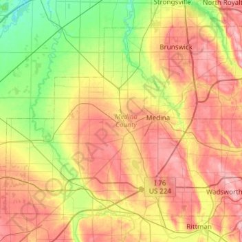
Name: Medina County topographic map, elevation, terrain.
Location: Medina County, Ohio, United States of America (40.98815 -82.17336 41.27715 -81.68494)
Average elevation: 306 m
Minimum elevation: 224 m
Maximum elevation: 405 m
Other topographic maps
Click on a map to view its topography, its elevation and its terrain.
Highland County
United States of America > Ohio
Highland County, Ohio, United States of America
Average elevation: 305 m
Williams County
United States of America > Ohio
Williams County, Ohio, United States of America
Average elevation: 259 m
Defiance County
United States of America > Ohio
Defiance County, Ohio, United States of America
Average elevation: 225 m
Beechgrove
United States of America > Ohio > Beechgrove
Beechgrove, Darke County, Ohio, United States of America
Average elevation: 330 m
Toledo
United States of America > Ohio > Toledo
Toledo, Lucas County, Ohio, United States of America
Average elevation: 185 m