
Bergen County topographic map
Interactive map
Click on the map to display elevation.
About this map
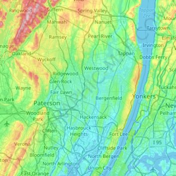
Name: Bergen County topographic map, elevation, terrain.
Location: Bergen County, New Jersey, United States (40.76203 -74.27248 41.13447 -73.89363)
Average elevation: 66 m
Minimum elevation: -4 m
Maximum elevation: 347 m
Bergen County's highest elevation is Bald Mountain near the New York state line in Mahwah, at 1,164 feet (355 m) above sea level. The county's lowest point is sea level, along the Hudson River, which in this region is a tidal estuary.
Other topographic maps
Click on a map to view its topography, its elevation and its terrain.
Hudson River
Hudson River, New Jersey, 12834:12871, United States
Average elevation: 297 m
Somerset County
Somerset County, New Jersey, United States
Average elevation: 72 m
Cape May County
Cape May County, New Jersey, United States
Average elevation: 1 m
West Milford
United States > New Jersey > Passaic County
West Milford, Passaic County, New Jersey, United States
Average elevation: 262 m
Camden County
Camden County, New Jersey, United States
Average elevation: 26 m
New Brunswick
United States > New Jersey > Middlesex County
New Brunswick, Middlesex County, New Jersey, United States
Average elevation: 25 m
Prospect Plains
United States > New Jersey > Middlesex County > Monroe Township
Prospect Plains, Monroe Township, Middlesex County, New Jersey, 08813, United States
Average elevation: 39 m
Sussex County
Sussex County, New Jersey, United States
Average elevation: 250 m
Ridgewood
United States > New Jersey > Bergen County
Ridgewood, Bergen County, New Jersey, United States
Average elevation: 51 m
Newark
United States > New Jersey > Essex County
Newark, Essex County, New Jersey, United States
Average elevation: 22 m
Bordentown Township
United States > New Jersey > Burlington County
Bordentown Township, Burlington County, New Jersey, 08505, United States
Average elevation: 18 m
Randolph Township
United States > New Jersey > Morris County
Randolph Township, Morris County, New Jersey, 07869, United States
Average elevation: 247 m
Atlantic City
United States > New Jersey > Atlantic County
Atlantic City, Atlantic County, New Jersey, 08401, United States
Average elevation: 1 m
Monmouth County
Monmouth County, New Jersey, United States
Average elevation: 19 m
Bedminster Township
United States > New Jersey > Somerset County
Bedminster Township, Somerset County, New Jersey, United States
Average elevation: 80 m
West Orange
United States > New Jersey > Essex County
West Orange, Essex County, New Jersey, 07052, United States
Average elevation: 108 m
Moorestown Township
United States > New Jersey > Burlington County
Moorestown Township, Burlington County, New Jersey, 08057, United States
Average elevation: 15 m
Morristown
United States > New Jersey > Morris County
Morristown, Morris County, New Jersey, 07960, United States
Average elevation: 123 m
Hunterdon County
Hunterdon County, New Jersey, United States
Average elevation: 120 m
Hardwick Township
United States > New Jersey > Warren County
Hardwick Township, Warren County, New Jersey, United States
Average elevation: 216 m
Hamburg
United States > New Jersey > Sussex County
Hamburg, Hardyston Township, Sussex County, New Jersey, 07419, United States
Average elevation: 156 m
West Haddonfield
United States > New Jersey > Camden County > Haddonfield
West Haddonfield, Haddonfield, Camden County, New Jersey, 08033, United States
Average elevation: 17 m
Cumberland County
Cumberland County, New Jersey, United States
Average elevation: 10 m
Maple Shade Township
United States > New Jersey > Burlington County
Maple Shade Township, Burlington County, New Jersey, 08052, United States
Average elevation: 14 m
Brick Township
United States > New Jersey > Ocean County
Brick Township, Ocean County, New Jersey, United States
Average elevation: 10 m
Belvidere
United States > New Jersey > Warren County
Belvidere, Warren County, New Jersey, United States
Average elevation: 94 m
Point Pleasant
United States > New Jersey > Ocean County
Point Pleasant, Ocean County, New Jersey, 08742, United States
Average elevation: 3 m
Mullica River
United States > New Jersey > Burlington County
Mullica River, Burlington County, New Jersey, United States
Average elevation: 17 m
Hazlet Township
United States > New Jersey > Monmouth County
Hazlet Township, Monmouth County, New Jersey, 07730, United States
Average elevation: 15 m
Pemberton
United States > New Jersey > Burlington County
Pemberton, Burlington County, New Jersey, United States
Average elevation: 19 m
Maurice River
United States > New Jersey > Cumberland County
Maurice River, Cumberland County, New Jersey, United States
Average elevation: 17 m
Somers Point
United States > New Jersey > Atlantic County
Somers Point, Atlantic County, New Jersey, 08244, United States
Average elevation: 3 m
Pine Lane
United States > New Jersey > Burlington County > Springfield Township
Pine Lane, Springfield Township, Burlington County, New Jersey, 08041, United States
Average elevation: 25 m
Manchester Township
United States > New Jersey > Ocean County
Manchester Township, Ocean County, New Jersey, United States
Average elevation: 34 m
Oaklyn
United States > New Jersey > Camden County
Oaklyn, Camden County, New Jersey, United States
Average elevation: 8 m
Woodcrest
United States > New Jersey > Camden County > Cherry Hill Township
Woodcrest, Cherry Hill Township, Camden County, New Jersey, 08003, United States
Average elevation: 26 m
Swain
United States > New Jersey > Cape May County > Middle Township
Swain, Middle Township, Cape May County, New Jersey, 08218, United States
Average elevation: 5 m
Meyersville
United States > New Jersey > Morris County > Long Hill Township
Meyersville, Long Hill Township, Morris County, New Jersey, 07933, United States
Average elevation: 77 m
Bloomingdale
United States > New Jersey > Passaic County
Bloomingdale, Passaic County, New Jersey, 07403, United States
Average elevation: 157 m
Raritan Township
United States > New Jersey > Hunterdon County
Raritan Township, Hunterdon County, New Jersey, 08822, United States
Average elevation: 110 m
Feaster Park
United States > New Jersey > Middlesex County > New Brunswick
Feaster Park, New Brunswick, Middlesex County, New Jersey, 08901, United States
Average elevation: 25 m
Sherbrook Estates
United States > New Jersey > Mercer County > West Windsor
Sherbrook Estates, West Windsor, Mercer County, New Jersey, 08550, United States
Average elevation: 27 m
Bergenfield
United States > New Jersey > Bergen County
Bergenfield, Bergen County, New Jersey, 07621, United States
Average elevation: 30 m
Lawrenceville
United States > New Jersey > Mercer County > Lawrence Township > Lawrenceville
Lawrenceville, Lawrence Township, Mercer County, New Jersey, United States
Average elevation: 50 m
Hainesport
United States > New Jersey > Burlington County
Hainesport, Hainesport Township, Burlington County, New Jersey, 08036, United States
Average elevation: 10 m
Roebling
United States > New Jersey > Burlington County > Florence Township
Roebling, Florence Township, Burlington County, New Jersey, 08554, United States
Average elevation: 11 m
Mullica Township
United States > New Jersey > Atlantic County
Mullica Township, Atlantic County, New Jersey, 08217, United States
Average elevation: 17 m
Lavallette
United States > New Jersey > Ocean County
Lavallette, Ocean County, New Jersey, United States
Average elevation: 1 m
Jacksonville
United States > New Jersey > Morris County > Kinnelon
Jacksonville, Kinnelon, Morris County, New Jersey, 07444, United States
Average elevation: 110 m
Avon-by-the-Sea
United States > New Jersey > Monmouth County
Avon-by-the-Sea, Monmouth County, New Jersey, 07717, United States
Average elevation: 3 m