
Randolph Township topographic map
Interactive map
Click on the map to display elevation.
About this map
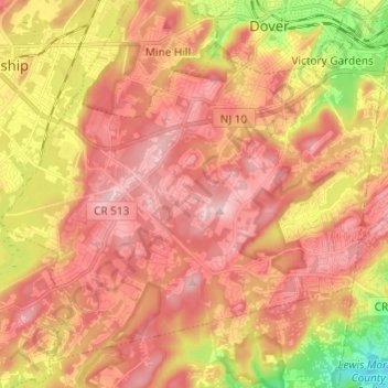
Name: Randolph Township topographic map, elevation, terrain.
Average elevation: 247 m
Minimum elevation: 97 m
Maximum elevation: 340 m
Other topographic maps
Click on a map to view its topography, its elevation and its terrain.
Morristown
United States > New Jersey > Morris County
Morristown, Morris County, New Jersey, 07960, United States
Average elevation: 123 m
Meyersville
United States > New Jersey > Morris County > Long Hill Township
Meyersville, Long Hill Township, Morris County, New Jersey, 07933, United States
Average elevation: 77 m
Jacksonville
United States > New Jersey > Morris County > Kinnelon
Jacksonville, Kinnelon, Morris County, New Jersey, 07444, United States
Average elevation: 110 m
Ledgewood
United States > New Jersey > Morris County > Roxbury Township
Ledgewood, Roxbury Township, Morris County, New Jersey, 07852, United States
Average elevation: 265 m
Denville
United States > New Jersey > Morris County
Denville, Morris County, New Jersey, 07834, United States
Average elevation: 177 m
Boonton Township
United States > New Jersey > Morris County
Boonton Township, Morris County, New Jersey, United States
Average elevation: 188 m
Shongum
United States > New Jersey > Morris County > Randolph Township
Shongum, Randolph Township, Morris County, New Jersey, 07869, United States
Average elevation: 248 m
Long Valley
United States > New Jersey > Morris County > Washington Township
Long Valley, Washington Township, Morris County, New Jersey, United States
Average elevation: 235 m
Flanders
United States > New Jersey > Morris County > Mount Olive
Flanders, Mount Olive, Morris County, New Jersey, 07836, United States
Average elevation: 255 m
Parsippany
United States > New Jersey > Morris County > Parsippany-Troy Hills
Parsippany, Parsippany-Troy Hills, Morris County, New Jersey, 07054, United States
Average elevation: 95 m
Dover
United States > New Jersey > Morris County
Dover, Morris County, New Jersey, 07801, United States
Average elevation: 205 m
Mount Fern
United States > New Jersey > Morris County > Randolph Township
Mount Fern, Randolph Township, Morris County, New Jersey, 07869, United States
Average elevation: 265 m
Mendham Township
United States > New Jersey > Morris County
Mendham Township, Morris County, New Jersey, United States
Average elevation: 179 m
Wharton
United States > New Jersey > Morris County
Wharton, Morris County, New Jersey, United States
Average elevation: 213 m
Kinnelon
United States > New Jersey > Morris County
Kinnelon, Morris County, New Jersey, 07405, United States
Average elevation: 196 m
Pequannock Township
United States > New Jersey > Morris County
Pequannock Township, Morris County, New Jersey, United States
Average elevation: 74 m
Rockaway River Wildlife Management Area
United States > New Jersey > Morris County > Jefferson Township
Rockaway River Wildlife Management Area, Jefferson Township, Morris County, New Jersey, United States
Average elevation: 276 m
Boonton Reservoir
United States > New Jersey > Morris County > Parsippany-Troy Hills
Boonton Reservoir, Parsippany-Troy Hills, Morris County, New Jersey, United States
Average elevation: 102 m
Boonton
United States > New Jersey > Morris County
Boonton, Morris County, New Jersey, 07005, United States
Average elevation: 141 m
Lake Hiawatha
United States > New Jersey > Morris County > Parsippany-Troy Hills
Lake Hiawatha, Parsippany-Troy Hills, Morris County, New Jersey, 07034, United States
Average elevation: 77 m
Lower Montville
United States > New Jersey > Morris County > Montville Township
Lower Montville, Montville Township, Morris County, New Jersey, 07045, United States
Average elevation: 84 m
Morris Township
United States > New Jersey > Morris County
Morris Township, Morris County, New Jersey, United States
Average elevation: 161 m
Rockaway
United States > New Jersey > Morris County
Rockaway, Morris County, New Jersey, United States
Average elevation: 196 m
Mine Hill
United States > New Jersey > Morris County
Mine Hill, Morris County, New Jersey, 07803, United States
Average elevation: 245 m
Long Hill Township
United States > New Jersey > Morris County
Long Hill Township, Morris County, New Jersey, United States
Average elevation: 77 m
Rolling Hill
United States > New Jersey > Morris County > Chatham Township
Rolling Hill, Chatham Township, Morris County, New Jersey, 07928, United States
Average elevation: 89 m
Pine Brook
United States > New Jersey > Morris County > Montville Township
Pine Brook, Montville Township, Morris County, New Jersey, 07058, United States
Average elevation: 56 m
Roxbury Township
United States > New Jersey > Morris County > Roxbury Township
Roxbury Township, Morris County, New Jersey, 07852, United States
Average elevation: 264 m
Montville Township
United States > New Jersey > Morris County
Montville Township, Morris County, New Jersey, United States
Average elevation: 115 m
New Vernon
United States > New Jersey > Morris County > Harding Township
New Vernon, Harding Township, Morris County, New Jersey, 07976, United States
Average elevation: 104 m
Washington Township
United States > New Jersey > Morris County
Washington Township, Morris County, New Jersey, United States
Average elevation: 244 m
Rockaway Valley
United States > New Jersey > Morris County > Boonton Township
Rockaway Valley, Boonton Township, Morris County, New Jersey, 07005, United States
Average elevation: 181 m
Petersburg
United States > New Jersey > Morris County > Jefferson Township
Petersburg, Jefferson Township, Morris County, New Jersey, 07438, United States
Average elevation: 297 m
Union Hill
United States > New Jersey > Morris County > Denville
Union Hill, Denville, Morris County, New Jersey, 07950, United States
Average elevation: 241 m
Mooney Mountain Park
United States > New Jersey > Morris County > Roxbury Township
Mooney Mountain Park, Hilltop Estates, Roxbury Township, Morris County, New Jersey, United States
Average elevation: 326 m
Morris Plains
United States > New Jersey > Morris County > Morris Plains
Morris Plains, Morris County, New Jersey, 07950, United States
Average elevation: 147 m
Floral Hill
United States > New Jersey > Morris County > Chatham Township > Floral Hill
Floral Hill, Chatham Township, Morris County, New Jersey, 07928, United States
Average elevation: 90 m
Butler
United States > New Jersey > Morris County
Butler, Morris County, New Jersey, United States
Average elevation: 144 m
Crestview
United States > New Jersey > Morris County > Madison > Crestview
Crestview, Madison, Morris County, New Jersey, 07928:07940, United States
Average elevation: 87 m
Chatham
United States > New Jersey > Morris County
Chatham, Morris County, New Jersey, United States
Average elevation: 76 m
Monroe
United States > New Jersey > Morris County > Hanover Township
Monroe, Hanover Township, Morris County, New Jersey, 07927, United States
Average elevation: 93 m
Chester
United States > New Jersey > Morris County
Chester, Morris County, New Jersey, United States
Average elevation: 250 m
Beach Glen
United States > New Jersey > Morris County > Rockaway Township > Beach Glen
Beach Glen, Rockaway Township, Morris County, New Jersey, 07842, United States
Average elevation: 209 m
Chester Township
United States > New Jersey > Morris County
Chester Township, Morris County, New Jersey, 07930, United States
Average elevation: 207 m
Roxbury Township
United States > New Jersey > Morris County > Roxbury Township
Roxbury Township, Morris County, New Jersey, United States
Average elevation: 268 m
Morristown
United States > New Jersey > Morris County
Morristown, Morris County, New Jersey, 07960, United States
Average elevation: 118 m
Mount Olive
United States > New Jersey > Morris County
Mount Olive, Morris County, New Jersey, United States
Average elevation: 280 m
Parsippany-Troy Hills
United States > New Jersey > Morris County
Parsippany-Troy Hills, Morris County, New Jersey, United States
Average elevation: 113 m
Brook Valley
United States > New Jersey > Morris County > Kinnelon
Brook Valley, Kinnelon, Morris County, New Jersey, 07405, United States
Average elevation: 221 m
Whippany
United States > New Jersey > Morris County > Hanover Township
Whippany, Hanover Township, Morris County, New Jersey, 07981, United States
Average elevation: 76 m