
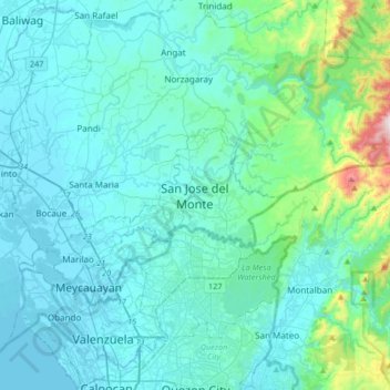
San Jose del Monte topographic map
Interactive map
Click on the map to display elevation.
About this map
Name: San Jose del Monte topographic map, elevation, terrain.
Average elevation: 106 m
Minimum elevation: -3 m
Maximum elevation: 981 m
The elevation of the city ranges from approximately 40 to 900 meters (130 to 2,950 ft) above sea level; the relief transitions from warm lowland to cool upland as one goes eastward. This is because the city is part of the Sierra Madre mountain range. Plains and river valley flats characterize the western and southwestern quadrant. The central portion and much of its eastern section are made up of undulating hills with low relief. High relief areas moderate slopes best describe its extreme eastern and northwestern quadrant. Slopes of 3%-8% are extensively found in the city, particularly on the western half. Slopes of 30%-50% comprise the smallest portion of the total land area.
Other topographic maps
Click on a map to view its topography, its elevation and its terrain.
Baliuag
Philippines > Bulacan > Baliuag
Baliuag, Bulacan, Central Luzon, 3006, Philippines
Average elevation: 15 m
Catulinan
Philippines > Bulacan > Baliwag
Catulinan, Baliwag, Bulacan, Central Luzon, 3006, Philippines
Average elevation: 14 m
Santa Maria
Santa Maria, Bulacan, Central Luzon, 3022, Philippines
Average elevation: 18 m
Longos
Philippines > Bulacan > Calumpit
Longos, Calumpit, Bulacan, Central Luzon, 3000, Philippines
Average elevation: 4 m
Bulihan
Philippines > Bulacan > Malolos
Bulihan, Malolos, Bulacan, Central Luzon, 3000, Philippines
Average elevation: 4 m
Masagana Homes
Philippines > Bulacan > Guiguinto
Masagana Homes, Guiguinto, Bulacan, Central Luzon, 3015, Philippines
Average elevation: 6 m
Cruz na Daan
Philippines > Bulacan > San Rafael
Cruz na Daan, San Rafael, Bulacan, Central Luzon, 3008, Philippines
Average elevation: 19 m
Frances
Philippines > Bulacan > Calumpit
Frances, Calumpit, Bulacan, Central Luzon, 3003, Philippines
Average elevation: 4 m
Pulong Yantok
Pulong Yantok, Bulacan, Central Luzon, 3012, Philippines
Average elevation: 67 m
Malolos
Malolos, Bulacan, Central Luzon, 3000, Philippines
Average elevation: 4 m
Angat River
Philippines > Bulacan > Hagonoy > Iba-Ibayo
Angat River, Abulalas, Iba-Ibayo, Hagonoy, Bulacan, Central Luzon, 3002, Philippines
Average elevation: 4 m
Sergio Bayan
Philippines > Bulacan > Calumpit
Sergio Bayan, Calumpit, Bulacan, Central Luzon, 3003, Philippines
Average elevation: 5 m
Taal
Philippines > Bulacan > Pulilan
Taal, Pulilan, Bulacan, Central Luzon, Philippines
Average elevation: 12 m
Gaya Gaya
Philippines > Bulacan > San Jose del Monte
Gaya Gaya, San Jose del Monte, Bulacan, Central Luzon, 3023, Philippines
Average elevation: 67 m
Piel
Philippines > Bulacan > Baliwag
Piel, Baliwag, Bulacan, Central Luzon, 3006, Philippines
Average elevation: 13 m
Tangos
Philippines > Bulacan > Baliwag
Tangos, Baliwag, Bulacan, Central Luzon, Philippines
Average elevation: 15 m
Gumaok
Philippines > Bulacan > San Jose del Monte
Gumaok, San Jose del Monte, Bulacan, Central Luzon, 3023, Philippines
Average elevation: 82 m
San Jose del Monte lone district
Philippines > Bulacan > San Jose del Monte
San Jose del Monte lone district, San Jose del Monte, Bulacan, Central Luzon, Philippines
Average elevation: 72 m
Norzagaray
Norzagaray, Bulacan, Central Luzon, 3013, Philippines
Average elevation: 66 m
Concepcion
Philippines > Bulacan > Baliwag
Concepcion, Baliwag, Bulacan, Central Luzon, 3006, Philippines
Average elevation: 15 m
Bulakan
Bulakan, Bulacan, Central Luzon, 3017, Philippines
Average elevation: 4 m
Meycauayan
Meycauayan, Bulacan, Central Luzon, 3020, Philippines
Average elevation: 27 m
Guiguinto
Guiguinto, Bulacan, Central Luzon, 3015, Philippines
Average elevation: 6 m
Pulong Sampaloc
Philippines > Bulacan > Doña Remedios Trinidad
Pulong Sampaloc, Doña Remedios Trinidad, Bulacan, Central Luzon, Philippines
Average elevation: 80 m
Makinabang
Philippines > Bulacan > Baliwag
Makinabang, Baliwag, Bulacan, Central Luzon, 3370, Philippines
Average elevation: 13 m
San Vicente
San Vicente, Bulacan, Central Luzon, 3011, Philippines
Average elevation: 18 m
Meycauayan River
Philippines > Bulacan > Valenzuela
Meycauayan River, Punturin, 1st District, Valenzuela, Northern Manila District, Bulacan, Metro Manila, 1447, Philippines
Average elevation: 13 m
San Jose del Monte
San Jose del Monte, Bulacan, Central Luzon, Philippines
Average elevation: 66 m
San Miguel River
Philippines > Bulacan > San Miguel
San Miguel River, San Miguel, Bulacan, Central Luzon, 3011, Philippines
Average elevation: 26 m
Balubad
Philippines > Bulacan > Bulakan
Balubad, Bulakan, Bulacan, Central Luzon, 3017, Philippines
Average elevation: 4 m
Plaridel
Plaridel, Bulacan, Central Luzon, 3004, Philippines
Average elevation: 9 m
San Martin de Porres
San Martin de Porres, Bulacan, Central Luzon, 3013, Philippines
Average elevation: 94 m
Sapang Palay Proper
Philippines > Bulacan > San Jose del Monte
Sapang Palay Proper, San Jose del Monte, Bulacan, Central Luzon, 3024, Philippines
Average elevation: 58 m
Balagtas
Balagtas, Bulacan, Central Luzon, 3016, Philippines
Average elevation: 6 m
Iba
Philippines > Bulacan > Meycauayan
Iba, Meycauayan, Bulacan, Central Luzon, 3020, Philippines
Average elevation: 17 m
Marilao River
Philippines > Bulacan > Meycauayan
Marilao River, Longos, Meycauayan, Bulacan, Central Luzon, 3020, Philippines
Average elevation: 3 m
Malolos
Malolos, Bulacan, Central Luzon, 3000, Philippines
Average elevation: 6 m
Pulilan
Pulilan, Bulacan, Central Luzon, 3005, Philippines
Average elevation: 10 m
Hagonoy
Hagonoy, Bulacan, Central Luzon, 3002, Philippines
Average elevation: 1 m
Tungkong Mangga
Philippines > Bulacan > San Jose del Monte
Tungkong Mangga, San Jose del Monte, Bulacan, Central Luzon, 3023, Philippines
Average elevation: 86 m
Meycauayan
Meycauayan, Bulacan, Central Luzon, 3020, Philippines
Average elevation: 14 m
Muzon
Philippines > Bulacan > Muzon
Muzon, Bulacan, Central Luzon, 3028, Philippines
Average elevation: 51 m
San Miguel
San Miguel, Bulacan, Central Luzon, 3011, Philippines
Average elevation: 22 m