
Tangos topographic map
Interactive map
Click on the map to display elevation.
About this map
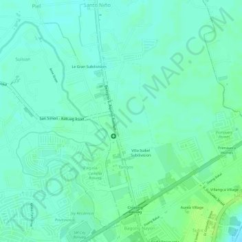
Name: Tangos topographic map, elevation, terrain.
Location: Tangos, Baliwag, Bulacan, Central Luzon, Philippines (14.96234 120.88592 14.98423 120.90379)
Average elevation: 15 m
Minimum elevation: 9 m
Maximum elevation: 22 m
Other topographic maps
Click on a map to view its topography, its elevation and its terrain.
Catulinan
Philippines > Bulacan > Baliwag
Catulinan, Baliwag, Bulacan, Central Luzon, 3006, Philippines
Average elevation: 14 m
Piel
Philippines > Bulacan > Baliwag
Piel, Baliwag, Bulacan, Central Luzon, 3006, Philippines
Average elevation: 13 m
Concepcion
Philippines > Bulacan > Baliwag
Concepcion, Baliwag, Bulacan, Central Luzon, 3006, Philippines
Average elevation: 15 m
Makinabang
Philippines > Bulacan > Baliwag
Makinabang, Baliwag, Bulacan, Central Luzon, 3370, Philippines
Average elevation: 13 m