
Make a donation
Gear up for your next adventure:
As an Amazon Associate, this site earns from qualifying purchases at no extra cost to you.
Lehigh County topographic map
Click on the map to display elevation.
Make a donation
Gear up for your next adventure:
As an Amazon Associate, this site earns from qualifying purchases at no extra cost to you.
Lehigh County
Lehigh County borders two Appalachian mountain ridges. To the north, the county borders Blue Mountain, which has an altitude of 1,300 to 1,604 feet (396 to 489 m). To the south, it is bordered by South Mountain, which has an altitude of 700 to 1,100 feet (210 to 340 m) and cuts through the southern portions of both Lehigh and Northampton counties. The Lehigh County's highest point is near Germansville at Bake Oven Knob, a mass of Tuscarora conglomeratic rocks that rise about 100 feet (30 m) above the main Blue Mountain ridge in northwestern Heidelberg Township.
Make a donation
Gear up for your next adventure:
As an Amazon Associate, this site earns from qualifying purchases at no extra cost to you.
About this map
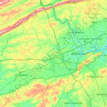
Name: Lehigh County topographic map, elevation, terrain.
Location: Lehigh County, Pennsylvania, United States (40.41848 -75.89192 40.78669 -75.33305)
Average elevation: 186 m
Minimum elevation: 64 m
Maximum elevation: 509 m
Make a donation
Gear up for your next adventure:
As an Amazon Associate, this site earns from qualifying purchases at no extra cost to you.
Other topographic maps
Click on a map to view its topography, its elevation and its terrain.
East Texas
United States > Pennsylvania > Lehigh County > Lower Macungie Township
Average elevation: 126 m
Valley Forge
United States > Pennsylvania > Chester County > Schuylkill Township
Average elevation: 78 m
Albrightsville
United States > Pennsylvania > Carbon County > Kidder Township
Average elevation: 498 m
Make a donation
Gear up for your next adventure:
As an Amazon Associate, this site earns from qualifying purchases at no extra cost to you.
Lake Keystone
United States > Pennsylvania > Armstrong County > Plumcreek Township
Keystone Lake (also known as Keystone Reservoir and Plum Creek Reservoir) is a reservoir in Armstrong County in the U.S. state of Pennsylvania. The elevation of Keystone Lake is 1,076 feet (328 m) above sea level.
Average elevation: 357 m
Brackney
United States > Pennsylvania > Susquehanna County > Silver Lake Township
Average elevation: 491 m
Dingmans Ferry
United States > Pennsylvania > Pike County > Delaware Township
Average elevation: 192 m
Make a donation
Gear up for your next adventure:
As an Amazon Associate, this site earns from qualifying purchases at no extra cost to you.
Middlebury Center
United States > Pennsylvania > Tioga County > Middlebury Township
Average elevation: 462 m
Woxall
United States > Pennsylvania > Montgomery County > Upper Salford Township
Average elevation: 98 m
Donegal Lake
United States > Pennsylvania > Westmoreland County > Donegal Township
Average elevation: 493 m
Make a donation
Gear up for your next adventure:
As an Amazon Associate, this site earns from qualifying purchases at no extra cost to you.
Centreville
United States > Pennsylvania > Lehigh County > Lower Macungie Township
Average elevation: 144 m
Bass Lake
United States > Pennsylvania > York County > Newberry Township > Valley Green
Average elevation: 143 m
Croydon Heights
United States > Pennsylvania > Bucks County > Bristol Township > Croydon
Average elevation: 10 m
Make a donation
Gear up for your next adventure:
As an Amazon Associate, this site earns from qualifying purchases at no extra cost to you.
Fitzwatertown
United States > Pennsylvania > Montgomery County > Upper Dublin Township
Average elevation: 86 m
Starview
United States > Pennsylvania > York County > East Manchester Township
Average elevation: 155 m
North Towanda
United States > Pennsylvania > Bradford County > North Towanda Township
Average elevation: 286 m
Make a donation
Gear up for your next adventure:
As an Amazon Associate, this site earns from qualifying purchases at no extra cost to you.
Make a donation
Gear up for your next adventure:
As an Amazon Associate, this site earns from qualifying purchases at no extra cost to you.
Make a donation
Gear up for your next adventure:
As an Amazon Associate, this site earns from qualifying purchases at no extra cost to you.
Freemont
United States > Pennsylvania > Chester County > West Nottingham Township
Average elevation: 115 m
Sturgeon
United States > Pennsylvania > Allegheny County > North Fayette Township
Average elevation: 334 m
Glade Mills
United States > Pennsylvania > Butler County > Middlesex Township
Average elevation: 359 m
Make a donation
Gear up for your next adventure:
As an Amazon Associate, this site earns from qualifying purchases at no extra cost to you.
Knickerbocker
United States > Pennsylvania > Chester County > Willistown Township
Average elevation: 127 m
Carlisle Springs
United States > Pennsylvania > Cumberland County > Middlesex Township
Average elevation: 182 m
Vance
United States > Pennsylvania > Washington County > South Strabane Township
Average elevation: 371 m
Sagamore Estates
United States > Pennsylvania > Pike County > Shohola Township
Average elevation: 412 m
Make a donation
Gear up for your next adventure:
As an Amazon Associate, this site earns from qualifying purchases at no extra cost to you.
Evansburg State Park
United States > Pennsylvania > Montgomery County > Worcester Township > Cedars
Average elevation: 70 m
Cross Fork
United States > Pennsylvania > Potter County > Stewardson Township
Average elevation: 467 m
Make a donation
Gear up for your next adventure:
As an Amazon Associate, this site earns from qualifying purchases at no extra cost to you.
Ithan
United States > Pennsylvania > Delaware County > Radnor Township > Saint Davids
Average elevation: 116 m
Drumore Center
United States > Pennsylvania > Lancaster County > Drumore Township
Average elevation: 175 m
Orefield
United States > Pennsylvania > Lehigh County > North Whitehall Township
Average elevation: 141 m
Make a donation
Gear up for your next adventure:
As an Amazon Associate, this site earns from qualifying purchases at no extra cost to you.
Mount Nebo Park
United States > Pennsylvania > Monroe County > East Stroudsburg > Twin Falls
Average elevation: 185 m
Blue Mountain
United States > Pennsylvania > Monroe County > Eldred Township
The ridge of Blue Mountain runs for 150 miles (240 km) through Pennsylvania, reaching an elevation of 2,270 feet (690 m) above sea level just north of the Pennsylvania Turnpike, near the borough of Newburg. Most of the ridgecrest, however, only reaches between 1,400 and 1,700 feet (430 and 520 m) in elevation.…
Average elevation: 242 m
Make a donation
Gear up for your next adventure:
As an Amazon Associate, this site earns from qualifying purchases at no extra cost to you.
Longwood Gardens
United States > Pennsylvania > Chester County > East Marlborough Township
Average elevation: 125 m
Nottingham County Park
United States > Pennsylvania > Chester County > West Nottingham Township
Average elevation: 137 m
Marble Hall
United States > Pennsylvania > Montgomery County > Whitemarsh Township
Average elevation: 64 m
Make a donation
Gear up for your next adventure:
As an Amazon Associate, this site earns from qualifying purchases at no extra cost to you.
Circleville
United States > Pennsylvania > Westmoreland County > North Huntingdon Township
Average elevation: 333 m
Make a donation
Gear up for your next adventure:
As an Amazon Associate, this site earns from qualifying purchases at no extra cost to you.
Chadds Ford Township
United States > Pennsylvania > Delaware County > Chadds Ford Township
Average elevation: 101 m
Strawberry Mansion
United States > Pennsylvania > Philadelphia County > Philadelphia
Average elevation: 31 m
Reinholds
United States > Pennsylvania > Lancaster County > West Cocalico Township
Average elevation: 159 m
Make a donation
Gear up for your next adventure:
As an Amazon Associate, this site earns from qualifying purchases at no extra cost to you.
Langhorne Gardens
United States > Pennsylvania > Bucks County > Middletown Township
Average elevation: 45 m
Make a donation
Gear up for your next adventure:
As an Amazon Associate, this site earns from qualifying purchases at no extra cost to you.
Hanover Junction
United States > Pennsylvania > York County > North Codorus Township
Average elevation: 187 m
Champion
United States > Pennsylvania > Allegheny County > North Fayette Township
Average elevation: 360 m
Make a donation
Gear up for your next adventure:
As an Amazon Associate, this site earns from qualifying purchases at no extra cost to you.
North Coplay
United States > Pennsylvania > Lehigh County > Whitehall > Cementon
Average elevation: 116 m
Fagleysville
United States > Pennsylvania > Montgomery County > New Hanover Township
Average elevation: 105 m
Kreidersville
United States > Pennsylvania > Northampton County > Allen Township
Average elevation: 151 m
Make a donation
Gear up for your next adventure:
As an Amazon Associate, this site earns from qualifying purchases at no extra cost to you.
Stiefler Corner
United States > Pennsylvania > Bedford County > Kimmel Township
Average elevation: 520 m
Make a donation
Gear up for your next adventure:
As an Amazon Associate, this site earns from qualifying purchases at no extra cost to you.
Leather Corner Post
United States > Pennsylvania > Lehigh County > Lowhill Township
Average elevation: 178 m
Welsh Mountain Nature Preserve
United States > Pennsylvania > Lancaster County > East Earl Township
Average elevation: 294 m
East Springfield
United States > Pennsylvania > Erie County > Springfield Township
Average elevation: 229 m
Make a donation
Gear up for your next adventure:
As an Amazon Associate, this site earns from qualifying purchases at no extra cost to you.
Raven Rock Mountain
United States > Pennsylvania > Adams County > Liberty Township
Average elevation: 312 m
Strickhousers
United States > Pennsylvania > York County > North Codorus Township
Average elevation: 205 m
Make a donation
Gear up for your next adventure:
As an Amazon Associate, this site earns from qualifying purchases at no extra cost to you.
Pocono Lake
United States > Pennsylvania > Monroe County > Tobyhanna Township
Average elevation: 543 m
Intercourse
United States > Pennsylvania > Lancaster County > Leacock Township
Average elevation: 127 m
Make a donation
Gear up for your next adventure:
As an Amazon Associate, this site earns from qualifying purchases at no extra cost to you.
East Waterford
United States > Pennsylvania > Juniata County > Tuscarora Township
Average elevation: 257 m
Make a donation
Gear up for your next adventure:
As an Amazon Associate, this site earns from qualifying purchases at no extra cost to you.
Make a donation
Gear up for your next adventure:
As an Amazon Associate, this site earns from qualifying purchases at no extra cost to you.
Faylor Lake
United States > Pennsylvania > Snyder County > Spring Township > Beaver Springs
Average elevation: 197 m
Gladwyne
United States > Pennsylvania > Montgomery County > Lower Merion Township
Average elevation: 92 m
11th and Pike Playground
United States > Pennsylvania > Berks County > Reading
Average elevation: 132 m
Make a donation
Gear up for your next adventure:
As an Amazon Associate, this site earns from qualifying purchases at no extra cost to you.