
Make a donation
Gear up for your next adventure:
As an Amazon Associate, this site earns from qualifying purchases at no extra cost to you.
Balochistan topographic map
Click on the map to display elevation.
Make a donation
Gear up for your next adventure:
As an Amazon Associate, this site earns from qualifying purchases at no extra cost to you.
About this map
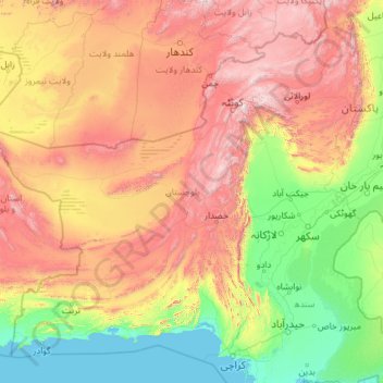
Name: Balochistan topographic map, elevation, terrain.
Location: Balochistan, Pakistan (24.73476 60.87286 32.06584 70.26187)
Average elevation: 753 m
Minimum elevation: -1 m
Maximum elevation: 3,436 m
Make a donation
Gear up for your next adventure:
As an Amazon Associate, this site earns from qualifying purchases at no extra cost to you.
Other topographic maps
Click on a map to view its topography, its elevation and its terrain.
K2
Pakistan > Gilgit-Baltistan > Shigar District
Also occasionally known as Mount Godwin-Austen, other nicknames for K2 are The King of Mountains and The Mountaineers' Mountain, as well as The Mountain of Mountains after prominent Italian climber Reinhold Messner titled his book about K2 the same. Although the summit of Everest is at a higher altitude, K2 is…
Average elevation: 7,474 m
Make a donation
Gear up for your next adventure:
As an Amazon Associate, this site earns from qualifying purchases at no extra cost to you.
Make a donation
Gear up for your next adventure:
As an Amazon Associate, this site earns from qualifying purchases at no extra cost to you.
Make a donation
Gear up for your next adventure:
As an Amazon Associate, this site earns from qualifying purchases at no extra cost to you.