
南伊豆町 topographic map
Interactive map
Click on the map to display elevation.
About this map
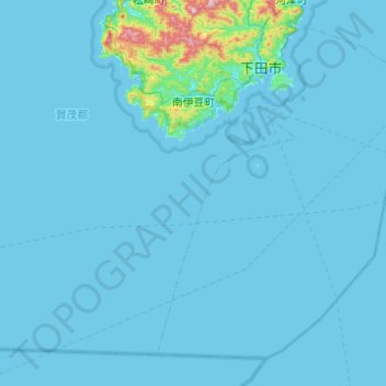
Name: 南伊豆町 topographic map, elevation, terrain.
Location: 南伊豆町, 賀茂郡, 静冈县/靜岡縣, 中部地方, 日本 (34.37650 138.49710 34.71628 138.99009)
Average elevation: 23 m
Minimum elevation: 0 m
Maximum elevation: 595 m
Other topographic maps
Click on a map to view its topography, its elevation and its terrain.