Geolocate

Frittenden topographic map

Click on the map to display elevation.

About this map

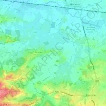
Name: Frittenden topographic map, elevation, terrain.

Location: Frittenden, Tunbridge Wells, Kent, England, United Kingdom (51.12056 0.54347 51.15902 0.64213)

Average elevation: 34 m

Minimum elevation: 16 m

Maximum elevation: 91 m

Other topographic maps

Click on a map to view its topography, its elevation and its terrain.

Brenchley

United Kingdom > England > Kent > Tunbridge Wells

Average elevation: 68 m

Iden Green

United Kingdom > England > Kent > Tunbridge Wells

Average elevation: 58 m

Cranbrook

United Kingdom > England > Kent > Tunbridge Wells

Average elevation: 76 m

East End

United Kingdom > England > Kent > Tunbridge Wells

Average elevation: 59 m

Linkhill

United Kingdom > England > Kent > Tunbridge Wells > Sandhurst

Average elevation: 22 m

Hook Green

United Kingdom > England > Kent > Tunbridge Wells

Average elevation: 86 m

Hurst Wood

United Kingdom > England > Kent > Tunbridge Wells > Rusthall

Average elevation: 101 m

Cranbrook

United Kingdom > England > Kent > Tunbridge Wells

Average elevation: 76 m

Langton Green

United Kingdom > England > Kent > Tunbridge Wells

Average elevation: 94 m

Matfield

United Kingdom > England > Kent > Tunbridge Wells

Average elevation: 82 m

Hartley

United Kingdom > England > Kent > Tunbridge Wells > Hartley

Average elevation: 94 m

Kilndown

United Kingdom > England > Kent > Tunbridge Wells > Kilndown

Average elevation: 71 m

Gear up for your next adventure:

🧤Thermal Gloves - Warm gloves for cold weather
🪓Camping Hand Axes - For processing wood during forest camping
Smart Watches for Hiking - Track performance on trails
📱Rugged Smartphones - Waterproof phones with long battery for offline mapping
🌄Sun Protection Gear - Gear to shield from strong sun

As an Amazon Associate, this site earns from qualifying purchases at no extra cost to you.