
Dunnottar topographic map
Interactive map
Click on the map to display elevation.
About this map
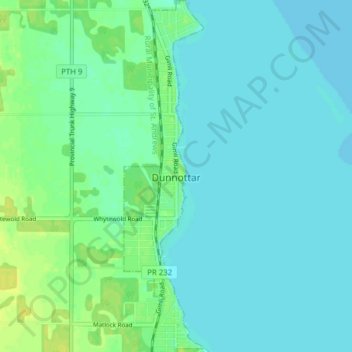
Name: Dunnottar topographic map, elevation, terrain.
Location: Dunnottar, Manitoba, Canada (50.42860 -96.96334 50.47818 -96.94566)
Average elevation: 220 m
Minimum elevation: 215 m
Maximum elevation: 232 m
Other topographic maps
Click on a map to view its topography, its elevation and its terrain.
Riding Mountain National Park
The climate in the Riding Mountain region is similar to that of other regions of southwestern Manitoba. Under the Köppen classification it has a continental climate. It includes grasslands, upland boreal and eastern deciduous forest ecosystems. The park has hot summers and cold winters, with annual rainfall…
Average elevation: 488 m
North Thomas Lake
Canada > Manitoba > Division No. 15 > Rural Municipality of Yellowhead
Average elevation: 596 m
Hecla
Canada > Manitoba > Division No. 18 > Unorganized Division No. 18 (East)
Average elevation: 220 m
Bakers Narrows
Canada > Manitoba > Division No. 21 > Unorganized Division No. 21
Average elevation: 297 m
Elphinstone
Canada > Manitoba > Division No. 15 > Rural Municipality of Yellowhead
Average elevation: 583 m
Bowsman
Canada > Manitoba > Division No. 20 > Rural Municipality of Minitonas – Bowsman
Average elevation: 310 m
Rowland Lake
Canada > Manitoba > Division No. 15 > Rural Municipality of Rosedale
Average elevation: 692 m
West Hawk Lake
Canada > Manitoba > Division No. 1 > Unorganized Division No. 1
Average elevation: 349 m
Hillside Beach
Canada > Manitoba > Division No. 1 > Rural Municipality of Alexander
Average elevation: 225 m
Easterville
Canada > Manitoba > Division No. 21 > Unorganized Division No. 21
Average elevation: 260 m
Clear Lake
Canada > Manitoba > Division No. 18 > Rural Municipality of Grahamdale
Average elevation: 251 m
Red River Floodway
Canada > Manitoba > Rural Municipality of Springfield > Winnipeg
Average elevation: 236 m
Libau
Canada > Manitoba > Division No. 13 > Rural Municipality of St. Clements
Average elevation: 223 m
Kerrs Lake
Canada > Manitoba > Division No. 15 > Municipality of Clanwilliam – Erickson
Average elevation: 670 m
Bird River
Canada > Manitoba > Division No. 1 > Rural Municipality of Alexander
Average elevation: 287 m
Poplarfield
Canada > Manitoba > Division No. 18 > Rural Municipality of Fisher
Average elevation: 270 m
Morning Lake
Canada > Manitoba > Division No. 20 > Unorganized Division No. 20 (South)
Average elevation: 633 m
Bird Lake
Canada > Manitoba > Division No. 20 > Unorganized Division No. 20 (South)
Average elevation: 657 m