
Thank you for supporting this site ❤️
Make a donation
Make a donation
Gear up for your next adventure:
As an Amazon Associate, this site earns from qualifying purchases at no extra cost to you.
Wawanesa topographic map
Click on the map to display elevation.
Thank you for supporting this site ❤️
Make a donation
Make a donation
Gear up for your next adventure:
As an Amazon Associate, this site earns from qualifying purchases at no extra cost to you.
About this map
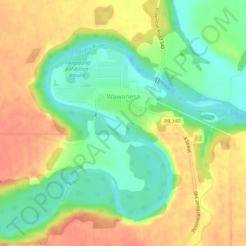
Name: Wawanesa topographic map, elevation, terrain.
Location: Wawanesa, Division No. 7, Manitoba, R0K 2G0, Canada (49.58396 -99.69675 49.60110 -99.66609)
Average elevation: 375 m
Minimum elevation: 349 m
Maximum elevation: 400 m
Thank you for supporting this site ❤️
Make a donation
Make a donation
Gear up for your next adventure:
As an Amazon Associate, this site earns from qualifying purchases at no extra cost to you.
Other topographic maps
Click on a map to view its topography, its elevation and its terrain.
Spruce Woods Provincial Park
Canada > Manitoba > Division No. 7 > Municipality of Glenboro – South Cypress
Average elevation: 357 m