
Make a donation
Gear up for your next adventure:
As an Amazon Associate, this site earns from qualifying purchases at no extra cost to you.
Chamarel topographic map
Click on the map to display elevation.
Make a donation
Gear up for your next adventure:
As an Amazon Associate, this site earns from qualifying purchases at no extra cost to you.
Chamarel
Chamarel is a village located in the western hills on the west coast of Mauritius at an elevation of about 850 feet (260 m) between Savanne and the Black river districts where the cascades are formed on the River du Capano flowing through an "amphitheater of abrupt rocks". It is a wooded plateau. The village is known for its "hushed bucolic vibe and cool breezes".[6][7][8] It is 6 kilometres (3.7 mi) from the coast.[9] Fauna noted in the forest surrounding the town is tortoise.[6]
Make a donation
Gear up for your next adventure:
As an Amazon Associate, this site earns from qualifying purchases at no extra cost to you.
About this map
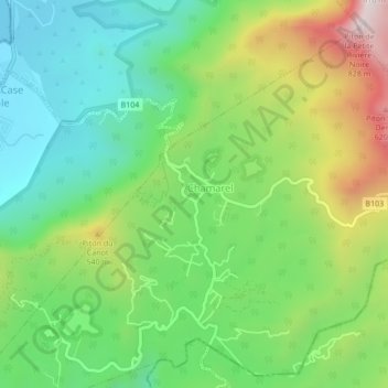
Name: Chamarel topographic map, elevation, terrain.
Location: Chamarel, Black River, Outer islands of Mauritius, Mauritius (-20.44599 57.36949 -20.40599 57.40949)
Average elevation: 284 m
Minimum elevation: 0 m
Maximum elevation: 806 m
Make a donation
Gear up for your next adventure:
As an Amazon Associate, this site earns from qualifying purchases at no extra cost to you.
Other topographic maps
Click on a map to view its topography, its elevation and its terrain.
Parc national des gorges de Rivière Noire
Mauritius > Black River > Vacoas-Phoenix
Average elevation: 324 m