
Piddinghoe topographic map
Interactive map
Click on the map to display elevation.
About this map
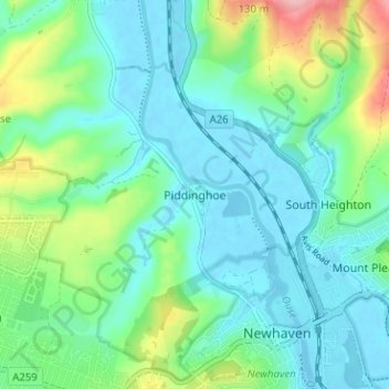
Name: Piddinghoe topographic map, elevation, terrain.
Location: Piddinghoe, Lewes, East Sussex, England, BN9 9AR, United Kingdom (50.78876 0.01501 50.82876 0.05501)
Average elevation: 33 m
Minimum elevation: -3 m
Maximum elevation: 138 m
Other topographic maps
Click on a map to view its topography, its elevation and its terrain.
Barcombe Cross
United Kingdom > England > East Sussex > Lewes
Barcombe Cross, Lewes, East Sussex, England, BN8 5DH, United Kingdom
Average elevation: 22 m
Swanborough
United Kingdom > England > East Sussex > Lewes > Iford
Swanborough, Iford, Lewes, East Sussex, England, BN7 3PG, United Kingdom
Average elevation: 53 m
Wivelsfield Green
United Kingdom > England > East Sussex > Lewes
Wivelsfield Green, Lewes, East Sussex, England, RH17 7RP, United Kingdom
Average elevation: 45 m
Broyle Side
United Kingdom > England > East Sussex > Lewes
Broyle Side, Lewes, East Sussex, England, BN8 5PA, United Kingdom
Average elevation: 19 m
Streat
United Kingdom > England > East Sussex > Lewes
Streat, Lewes, East Sussex, England, United Kingdom
Average elevation: 78 m
Plumpton Green
United Kingdom > England > East Sussex > Lewes
Plumpton Green, Lewes, East Sussex, England, BN7 3BU, United Kingdom
Average elevation: 45 m
Ditchling
United Kingdom > England > East Sussex > Lewes > Ditchling
Ditchling, Lewes, East Sussex, England, United Kingdom
Average elevation: 84 m
Ringmer
United Kingdom > England > East Sussex > Lewes
Ringmer, Lewes, East Sussex, England, United Kingdom
Average elevation: 22 m
Peacehaven
United Kingdom > England > East Sussex > Lewes
Peacehaven, Lewes, East Sussex, England, United Kingdom
Average elevation: 40 m
Kingston Near Lewes
United Kingdom > England > East Sussex > Lewes > Kingston Near Lewes
Kingston Near Lewes, Lewes, East Sussex, England, United Kingdom
Average elevation: 65 m
South Heighton
United Kingdom > England > East Sussex > Lewes > South Heighton
South Heighton, Lewes, East Sussex, England, BN9 0HL, United Kingdom
Average elevation: 37 m
Ditchling Beacon
United Kingdom > England > East Sussex > Lewes
Ditchling Beacon, Lewes, East Sussex, England, BN6 8XE, United Kingdom
Average elevation: 144 m
Cooksbridge
United Kingdom > England > East Sussex > Lewes > Cooksbridge
Cooksbridge, Lewes, East Sussex, South East England, England, BN8 4SY, United Kingdom
Average elevation: 38 m
Chailey
United Kingdom > England > East Sussex > Lewes
Chailey, Lewes, East Sussex, England, United Kingdom
Average elevation: 40 m
Hamsey
United Kingdom > England > East Sussex > Lewes > Cooksbridge
Hamsey, Cooksbridge, Lewes, East Sussex, England, United Kingdom
Average elevation: 34 m
Barcombe
United Kingdom > England > East Sussex > Lewes
Barcombe, Lewes, East Sussex, England, United Kingdom
Average elevation: 22 m
Falmer
United Kingdom > England > East Sussex > Lewes > Falmer
Falmer, Lewes, East Sussex, England, United Kingdom
Average elevation: 116 m
Westmeston
United Kingdom > England > East Sussex > Lewes > Westmeston
Westmeston, Lewes, East Sussex, South East England, England, BN6 8RJ, United Kingdom
Average elevation: 116 m
Firle
United Kingdom > England > East Sussex > Lewes
Firle, Lewes, East Sussex, England, United Kingdom
Average elevation: 54 m
Newick
United Kingdom > England > East Sussex > Lewes
Newick, Lewes, East Sussex, England, United Kingdom
Average elevation: 32 m
Glynde
United Kingdom > England > East Sussex > Lewes
Glynde, Lewes, East Sussex, England, United Kingdom
Average elevation: 31 m
North Chailey
United Kingdom > England > East Sussex > Lewes
North Chailey, Lewes, East Sussex, England, BN8 4HA, United Kingdom
Average elevation: 40 m
Telscombe
United Kingdom > England > East Sussex > Lewes
Telscombe, Lewes, East Sussex, England, United Kingdom
Average elevation: 55 m