Geolocate
Thank you for supporting this site ❤️Make a donation

Kilruddery Deerpark topographic map

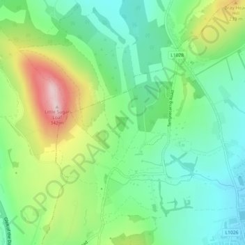
Click on the map to display elevation.

About this map

Name: Kilruddery Deerpark topographic map, elevation, terrain.

Location: Kilruddery Deerpark, Delgany ED, The Municipal District of Greystones, County Wicklow, Leinster, Ireland (53.16007 -6.11318 53.16876 -6.09424)

Average elevation: 132 m

Minimum elevation: 32 m

Maximum elevation: 331 m

Other topographic maps

Click on a map to view its topography, its elevation and its terrain.

Togher Beg

Ireland > County Wicklow

Togher Beg, Togher ED, The Municipal District of Wicklow, County Wicklow, Leinster, A98 P635, Ireland

Average elevation: 239 m

Knocksink

Ireland > County Wicklow

Knocksink, Enniskerry ED, The Municipal District of Bray, County Wicklow, Leinster, Ireland

Average elevation: 122 m

Kindlestown Hill

Ireland > County Wicklow

Kindlestown Hill, The Municipal District of Greystones, County Wicklow, Leinster, A63 A039, Ireland

Average elevation: 119 m

Roundwood

Ireland > County Wicklow

Roundwood, The Municipal District of Wicklow, County Wicklow, Leinster, Ireland

Average elevation: 242 m

Lugduff

Ireland > County Wicklow

Lugduff, Tinahely ED, The Municipal District of Baltinglass, County Wicklow, Leinster, Ireland

Average elevation: 111 m

Tinahely

Ireland > County Wicklow

Tinahely, Tinahely ED, The Municipal District of Baltinglass, County Wicklow, Leinster, Ireland

Average elevation: 128 m

Lugduff

Ireland > County Wicklow

Lugduff, The Municipal District of Wicklow, County Wicklow, Leinster, Ireland

Average elevation: 458 m

Glencree

Ireland > County Wicklow

Glencree, The Municipal District of Bray, County Wicklow, Leinster, Ireland

Average elevation: 358 m

Roundwood

Ireland > County Wicklow

Roundwood, Oldtown ED, The Municipal District of Wicklow, County Wicklow, Leinster, Ireland

Average elevation: 227 m

Kilcoole

Ireland > County Wicklow

Kilcoole, Kilcoole ED, The Municipal District of Greystones, County Wicklow, Leinster, Ireland

Average elevation: 29 m

Delgany

Ireland > County Wicklow

Delgany, The Municipal District of Greystones, County Wicklow, Leinster, A63 W953, Ireland

Average elevation: 87 m

Blessington

Ireland > County Wicklow

Blessington, The Municipal District of Baltinglass, County Wicklow, Leinster, W91 AC86, Ireland

Average elevation: 223 m

Bray

Ireland > County Wicklow

Bray, The Municipal District of Bray, County Wicklow, Leinster, A98 V827, Ireland

Average elevation: 58 m

Enniskerry

Ireland > County Wicklow

Enniskerry, The Municipal District of Bray, County Wicklow, Leinster, A98 FK10, Ireland

Average elevation: 118 m

Kilquade

Ireland > County Wicklow

Kilquade, Kilcoole ED, The Municipal District of Greystones, County Wicklow, Leinster, Ireland

Average elevation: 61 m

Wicklow Mountains National Park

Ireland > County Wicklow

Wicklow Mountains National Park, County Wicklow, Leinster, Ireland

Average elevation: 322 m

In order to remain free and to keep improving, this site uses cookies created by Google to compile visit statistics and display personalized advertisements.

How is the collected data used?