
Eastbourne topographic map
Click on the map to display elevation.
About this map
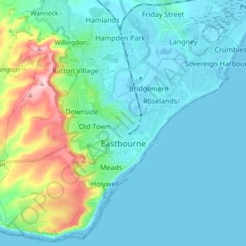
Name: Eastbourne topographic map, elevation, terrain.
Location: Eastbourne, East Sussex, England, United Kingdom (50.73343 0.20935 50.81308 0.33998)
Average elevation: 36 m
Minimum elevation: -6 m
Maximum elevation: 198 m
Other topographic maps
Click on a map to view its topography, its elevation and its terrain.
Ashdown Forest
United Kingdom > England > East Sussex > Wealden
Ashdown Forest is an ancient area of open heathland occupying the highest sandy ridge-top of the High Weald Area of Outstanding Natural Beauty. It is situated 30 miles (48 km) south of London in the county East Sussex, England. Rising to an elevation of 732 feet (223 m) above sea level, its heights provide…
Average elevation: 117 m
Punnetts Town Recreation Ground
United Kingdom > England > East Sussex > Wealden > Punnett's Town > Chapel Cross
Average elevation: 125 m
Highwoods SSSI
United Kingdom > England > East Sussex > Rother > Bexhill-on-Sea
Average elevation: 28 m
Wick Street
United Kingdom > England > East Sussex > Lewes > Firle > Wick Street
Average elevation: 36 m
Ditchling Beacon
United Kingdom > England > East Sussex > Lewes
Ditchling Beacon is the highest point in East Sussex, England, with an elevation of 248 m (814 ft). It is south of Ditchling and to the north-east of Brighton. It is a large chalk hill with a particularly steep northern face, covered with open grassland and sheep-grazing areas. It is the third-highest point on…
Average elevation: 144 m
Colemans Hatch
United Kingdom > England > East Sussex > Wealden > Upper Hartfield
Average elevation: 98 m
Fairlight Glen Naturist Beach
United Kingdom > England > East Sussex > Hastings
Average elevation: 61 m
East Chiltington
United Kingdom > England > East Sussex > Lewes > East Chiltington
Average elevation: 49 m
High Cross
United Kingdom > England > East Sussex > Wealden District > Rotherfield > High Cross
Average elevation: 129 m
Furner's Green
United Kingdom > England > East Sussex > Wealden District > Danehill > Furner's Green
Average elevation: 62 m
Chalvington
United Kingdom > England > East Sussex > Wealden District > Chalvington
Average elevation: 19 m
Kingston Near Lewes
United Kingdom > England > East Sussex > Lewes > Kingston Near Lewes
Average elevation: 65 m
Three Cups Corner
United Kingdom > England > East Sussex > Wealden District > Punnett's Town
Average elevation: 110 m
Frant Lakes
United Kingdom > England > East Sussex > Wealden > Bells Yew Green
Average elevation: 110 m
Heathfield Park
United Kingdom > England > East Sussex > Wealden > Cade Street
Average elevation: 132 m
Old Heathfield
United Kingdom > England > East Sussex > Wealden > Cade Street
Average elevation: 119 m
Broadwater Warren Nature Reserve
United Kingdom > England > East Sussex > Wealden > Groombridge
Average elevation: 84 m
Chuck Hatch
United Kingdom > England > East Sussex > Wealden > Upper Hartfield
Average elevation: 112 m
Northbridge Street
United Kingdom > England > East Sussex > Rother > Robertsbridge
Average elevation: 40 m
Sheffield Green
United Kingdom > England > East Sussex > Wealden > Sheffield Park
Average elevation: 50 m