
Hulunbuir topographic map
Interactive map
Click on the map to display elevation.
About this map
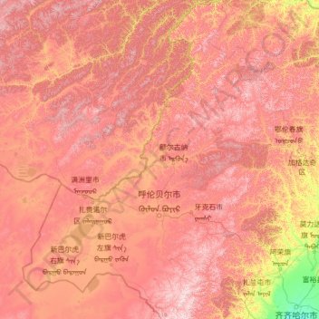
Name: Hulunbuir topographic map, elevation, terrain.
Location: Hulunbuir, Inner Mongolia, China (47.09442 115.52037 53.33289 126.06980)
Average elevation: 705 m
Minimum elevation: 137 m
Maximum elevation: 1,632 m
Other topographic maps
Click on a map to view its topography, its elevation and its terrain.
Dahewan
China > Inner Mongolia > Hulunbuir
Dahewan, Zalantun City, Hulunbuir, Inner Mongolia, China
Average elevation: 287 m
Nomonhan
China > Inner Mongolia > Hulunbuir
Nomonhan, Hulunbuir, Inner Mongolia, China
Average elevation: 744 m
Hulunbuir
China > Inner Mongolia > Hulunbuir
Hulunbuir, Hailar District, Hulunbuir, Inner Mongolia, 021000, China
Average elevation: 643 m