
Dahewan topographic map
Interactive map
Click on the map to display elevation.
About this map
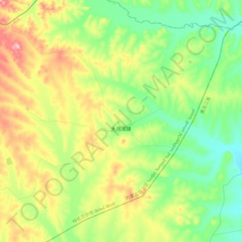
Name: Dahewan topographic map, elevation, terrain.
Location: Dahewan, Zalantun City, Hulunbuir, Inner Mongolia, China (47.73530 122.93314 47.97774 123.29068)
Average elevation: 287 m
Minimum elevation: 195 m
Maximum elevation: 480 m
Other topographic maps
Click on a map to view its topography, its elevation and its terrain.
Nomonhan
China > Inner Mongolia > Hulunbuir
Nomonhan, Hulunbuir, Inner Mongolia, China
Average elevation: 744 m
Hulunbuir
China > Inner Mongolia > Hulunbuir
Hulunbuir, Hailar District, Hulunbuir, Inner Mongolia, 021000, China
Average elevation: 643 m