
Puncak Jaya topographic map
Interactive map
Click on the map to display elevation.
About this map
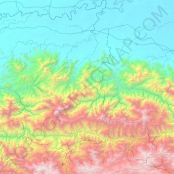
Name: Puncak Jaya topographic map, elevation, terrain.
Location: Puncak Jaya, Central Papua, Western New Guinea, Indonesia (-3.87327 137.43507 -2.98305 138.30178)
Average elevation: 1,194 m
Minimum elevation: 34 m
Maximum elevation: 4,082 m
Other topographic maps
Click on a map to view its topography, its elevation and its terrain.
Nayaro
Indonesia > Central Papua > Mimika
Nayaro, Mimika, Central Papua, Western New Guinea, Indonesia
Average elevation: 100 m
Bibida
Indonesia > Central Papua > Paniai
Bibida, Paniai, Central Papua, Western New Guinea, Indonesia
Average elevation: 3,405 m
Enarotali
Indonesia > Central Papua > Paniai
Enarotali, Paniai, Central Papua, Western New Guinea, 98700, Indonesia
Average elevation: 1,856 m
Puncak
Puncak, Central Papua, Western New Guinea, Indonesia
Average elevation: 1,680 m