
Evesham topographic map
Interactive map
Click on the map to display elevation.
About this map
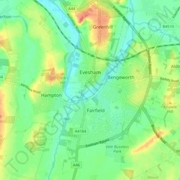
Name: Evesham topographic map, elevation, terrain.
Location: Evesham, Wychavon, Worcestershire, England, United Kingdom (52.06482 -1.97940 52.11354 -1.90225)
Average elevation: 38 m
Minimum elevation: 18 m
Maximum elevation: 70 m
Other topographic maps
Click on a map to view its topography, its elevation and its terrain.
South Littleton
United Kingdom > England > Worcestershire > Wychavon
South Littleton, Wychavon, Worcestershire, England, United Kingdom
Average elevation: 38 m
Kemerton
United Kingdom > England > Worcestershire > Wychavon
Kemerton, Wychavon, Worcestershire, England, United Kingdom
Average elevation: 85 m
Wychavon
United Kingdom > England > Worcestershire > Wychavon
Wychavon, Worcestershire, England, United Kingdom
Average elevation: 68 m