
South Littleton topographic map
Interactive map
Click on the map to display elevation.
About this map
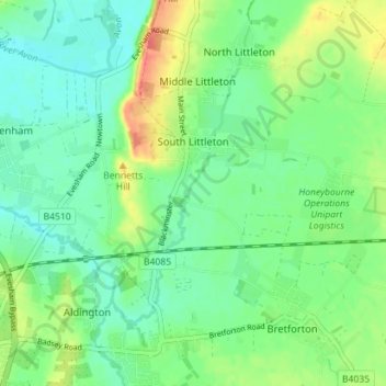
Name: South Littleton topographic map, elevation, terrain.
Average elevation: 38 m
Minimum elevation: 21 m
Maximum elevation: 71 m
Other topographic maps
Click on a map to view its topography, its elevation and its terrain.
Evesham
United Kingdom > England > Worcestershire > Wychavon
Evesham, Wychavon, Worcestershire, England, United Kingdom
Average elevation: 38 m
Kemerton
United Kingdom > England > Worcestershire > Wychavon
Kemerton, Wychavon, Worcestershire, England, United Kingdom
Average elevation: 85 m
Wychavon
United Kingdom > England > Worcestershire > Wychavon
Wychavon, Worcestershire, England, United Kingdom
Average elevation: 68 m
Hill End
United Kingdom > England > Worcestershire > Wychavon
Hill End, Wychavon, Worcestershire, England, WR9 8LJ, United Kingdom
Average elevation: 47 m