
Watauga County topographic map
Interactive map
Click on the map to display elevation.
About this map
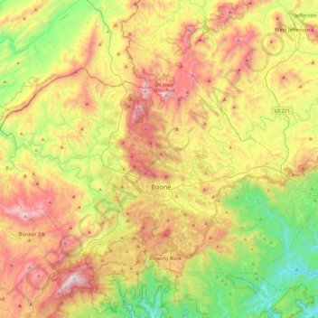
Name: Watauga County topographic map, elevation, terrain.
Location: Watauga County, North Carolina, United States (36.11147 -81.91812 36.39129 -81.45580)
Average elevation: 984 m
Minimum elevation: 378 m
Maximum elevation: 1,777 m
Watauga County is extremely mountainous, and all of the county's terrain is located within the Appalachian Mountains range. The highest point in the county is Calloway Peak, the highest peak of Grandfather Mountain (shared with the adjacent counties of Avery and Caldwell), which rises to 5,964 feet (1,818 meters) above sea level. At an elevation of 5,506 feet (1,678 meters) above sea level, Beech Mountain is the highest incorporated community east of the Mississippi River. Boone, the county's largest city and county seat, has the highest elevation (3,333 feet) of any city over 10,000 population in the Eastern United States.
Other topographic maps
Click on a map to view its topography, its elevation and its terrain.
Highlands
United States > North Carolina > Macon County > Highlands
Highlands, Macon County, North Carolina, 28741, United States
Average elevation: 1,090 m
Outer Banks
United States > North Carolina > Dare County
Outer Banks, Dare County, North Carolina, 27982, United States
Average elevation: 0 m
Buncombe County
United States > North Carolina
Buncombe County, North Carolina, United States
Average elevation: 839 m
Appalachian Mountains
United States > North Carolina > Yancey County
Appalachian Mountains, Yancey County, North Carolina, United States
Average elevation: 1,463 m
Bald Head Island
United States > North Carolina > Brunswick County > Bald Head Island
Bald Head Island, Brunswick County, North Carolina, 28461, United States
Average elevation: 3 m
Chapel Hill
United States > North Carolina > Orange County
Chapel Hill, Orange County, North Carolina, United States
Average elevation: 126 m
Durham County
United States > North Carolina
Durham County, North Carolina, United States
Average elevation: 128 m
Charlotte
United States > North Carolina > Mecklenburg County
Charlotte, Mecklenburg County, North Carolina, United States
Average elevation: 207 m
Murphy
United States > North Carolina > Cherokee County
Murphy, Cherokee County, North Carolina, United States
Average elevation: 514 m
Forsyth County
United States > North Carolina
Forsyth County, North Carolina, United States
Average elevation: 258 m
Brunswick County
United States > North Carolina
Brunswick County, North Carolina, United States
Average elevation: 9 m
New Hanover County
United States > North Carolina
New Hanover County, North Carolina, United States
Average elevation: 4 m
Mecklenburg County
United States > North Carolina
Mecklenburg County, North Carolina, United States
Average elevation: 208 m
Cherokee County
United States > North Carolina
Cherokee County, North Carolina, United States
Average elevation: 655 m
Waynesville
United States > North Carolina > Haywood County
Waynesville, Haywood County, North Carolina, 28786, United States
Average elevation: 921 m
Blue Ridge Parkway
United States > North Carolina > Watauga County
Blue Ridge Parkway, Watauga County, North Carolina, United States
Average elevation: 505 m
Beaufort County
United States > North Carolina
Beaufort County, North Carolina, United States
Average elevation: 7 m
Pender County
United States > North Carolina
Pender County, North Carolina, United States
Average elevation: 12 m
Ashe County
United States > North Carolina
Ashe County, North Carolina, United States
Average elevation: 952 m
Chatham County
United States > North Carolina
Chatham County, North Carolina, United States
Average elevation: 132 m
Onslow County
United States > North Carolina
Onslow County, North Carolina, United States
Average elevation: 11 m
Guilford County
United States > North Carolina
Guilford County, North Carolina, United States
Average elevation: 239 m
Burnsville
United States > North Carolina > Yancey County
Burnsville, Yancey County, North Carolina, United States
Average elevation: 882 m
Greensboro
United States > North Carolina > Guilford County
Greensboro, Guilford County, North Carolina, United States
Average elevation: 242 m
Rowan County
United States > North Carolina
Rowan County, North Carolina, United States
Average elevation: 228 m
Brevard
United States > North Carolina > Transylvania County
Brevard, Transylvania County, North Carolina, United States
Average elevation: 745 m
Fayetteville
United States > North Carolina > Cumberland County
Fayetteville, Cumberland County, North Carolina, United States
Average elevation: 48 m
Cabarrus County
United States > North Carolina
Cabarrus County, North Carolina, United States
Average elevation: 202 m
Sylva
United States > North Carolina > Jackson County
Sylva, Jackson County, North Carolina, United States
Average elevation: 708 m
Carteret County
United States > North Carolina
Carteret County, North Carolina, United States
Average elevation: 2 m
Concord
United States > North Carolina > Cabarrus County
Concord, Cabarrus County, North Carolina, United States
Average elevation: 201 m
Stokes County
United States > North Carolina
Stokes County, North Carolina, United States
Average elevation: 294 m
Ocracoke
United States > North Carolina > Hyde County > Ocracoke
Ocracoke, Hyde County, North Carolina, 27960, United States
Average elevation: 1 m
Calabash
United States > North Carolina > Brunswick County
Calabash, Brunswick County, North Carolina, United States
Average elevation: 6 m
Carr
United States > North Carolina > Orange County
Carr, Orange County, North Carolina, United States
Average elevation: 214 m
Holden Beach
United States > North Carolina > Brunswick County
Holden Beach, Brunswick County, North Carolina, United States
Average elevation: 3 m
Surf City
United States > North Carolina > Pender County
Surf City, Pender County, North Carolina, United States
Average elevation: 10 m
Winston-Salem
United States > North Carolina > Forsyth County
Winston-Salem, Forsyth County, North Carolina, United States
Average elevation: 263 m
Pittsboro
United States > North Carolina > Chatham County
Pittsboro, Chatham County, North Carolina, 27312, United States
Average elevation: 135 m
West Marion
United States > North Carolina > McDowell County
West Marion, McDowell County, North Carolina, 28752, United States
Average elevation: 449 m
Yancey County
United States > North Carolina
Yancey County, North Carolina, United States
Average elevation: 968 m
Franklinville
United States > North Carolina > Randolph County
Franklinville, Randolph County, North Carolina, United States
Average elevation: 163 m
Tar Heel
United States > North Carolina > Bladen County
Tar Heel, Bladen County, North Carolina, United States
Average elevation: 35 m
Marshall
United States > North Carolina > Madison County
Marshall, Madison County, North Carolina, United States
Average elevation: 609 m
Dare County
United States > North Carolina
Dare County, North Carolina, United States
Average elevation: 1 m
Dobson
United States > North Carolina > Surry County
Dobson, Surry County, North Carolina, United States
Average elevation: 351 m
Oak Cliffs
United States > North Carolina > Cabarrus County
Oak Cliffs, Cabarrus County, North Carolina, 28124, United States
Average elevation: 189 m
Berryland
United States > North Carolina > Orange County
Berryland, Orange County, North Carolina, United States
Average elevation: 187 m
Franklin
United States > North Carolina > Macon County
Franklin, Macon County, North Carolina, 28734, United States
Average elevation: 675 m
Apex
United States > North Carolina > Wake County
Apex, Wake County, North Carolina, 27502, United States
Average elevation: 115 m