
Wales topographic map
Interactive map
Click on the map to display elevation.
About this map
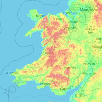
Name: Wales topographic map, elevation, terrain.
Location: Wales, United Kingdom (51.22903 -5.80773 53.63500 -2.64986)
Average elevation: 99 m
Minimum elevation: 0 m
Maximum elevation: 1,001 m
Much of Wales' diverse landscape is mountainous, particularly in the north and central regions. The mountains were shaped during the last ice age, the Devensian glaciation. The highest mountains in Wales are in Snowdonia (Eryri), of which five are over 1,000 m (3,300 ft). The highest of these is Snowdon (Yr Wyddfa), at 1,085 m (3,560 ft). The 14 Welsh mountains, or 15 if including Carnedd Gwenllian – often discounted because of its low topographic prominence – over 3,000 feet (910 metres) high are known collectively as the Welsh 3000s and are located in a small area in the north-west. The highest outside the 3000s is Aran Fawddwy, at 905 metres (2,969 feet), in the south of Snowdonia. The Brecon Beacons (Bannau Brycheiniog) are in the south (highest point Pen y Fan, at 886 metres (2,907 feet)), and are joined by the Cambrian Mountains in Mid Wales (highest point Pumlumon, at 752 metres (2,467 feet)).
Other topographic maps
Click on a map to view its topography, its elevation and its terrain.
Itchen Abbas
United Kingdom > England > Hampshire > Winchester
Itchen Abbas, Winchester, Hampshire, England, SO21 1DJ, United Kingdom
Average elevation: 81 m
Woodford Halse
United Kingdom > England > West Northamptonshire
Woodford Halse, West Northamptonshire, England, NN11 3NS, United Kingdom
Average elevation: 154 m
Cornwall
United Kingdom > England > Fairy Cross
Cornwall, Broadoak, Fairy Cross, Cornwall, South West England, England, United Kingdom
Average elevation: 49 m
High Wycombe
United Kingdom > England > Buckinghamshire
High Wycombe, Buckinghamshire, England, United Kingdom
Average elevation: 124 m
Winchester
United Kingdom > England > Hampshire
Winchester, Hampshire, England, United Kingdom
Average elevation: 73 m
Barton-upon-Humber
United Kingdom > England > North Lincolnshire
Barton-upon-Humber, North Lincolnshire, England, DN18 5QP, United Kingdom
Average elevation: 24 m
Culteuchar
United Kingdom > Scotland > Perth and Kinross > Perth
Culteuchar, Perth, Perth and Kinross, Scotland, PH2 9HL, United Kingdom
Average elevation: 194 m
Compton
United Kingdom > England > West Sussex > Chichester
Compton, Chichester, West Sussex, England, United Kingdom
Average elevation: 105 m
Runcorn
United Kingdom > England > Halton
Runcorn, Halton, Liverpool City Region, England, United Kingdom
Average elevation: 21 m
Tring
United Kingdom > England > Hertfordshire > Dacorum
Tring, Dacorum, Hertfordshire, England, United Kingdom
Average elevation: 168 m
St Andrews
United Kingdom > Scotland > Fife
St Andrews, Fife, Scotland, KY16 9PA, United Kingdom
Average elevation: 38 m
Wimbledon
Wimbledon, Greater London, England, SW19 7NL, United Kingdom
Average elevation: 26 m
Bridge of Earn
United Kingdom > Scotland > Perth and Kinross
Bridge of Earn, Perth and Kinross, Scotland, PH2 9PL, United Kingdom
Average elevation: 70 m
Painswick
United Kingdom > England > Gloucestershire
Painswick, Stroud, Gloucestershire, England, United Kingdom
Average elevation: 163 m
Hathersage
United Kingdom > England > Derbyshire > Derbyshire Dales
Hathersage, Derbyshire Dales, Derbyshire, England, United Kingdom
Average elevation: 311 m
Skipton
United Kingdom > England > North Yorkshire
Skipton, North Yorkshire, England, United Kingdom
Average elevation: 173 m
Wakefield
Wakefield, West Yorkshire, England, United Kingdom
Average elevation: 88 m
Malvern
United Kingdom > England > Worcestershire > Malvern Hills
Malvern, Malvern Hills, Worcestershire, England, WR14 2HX, United Kingdom
Average elevation: 95 m
West Lulworth
United Kingdom > England > Dorset
West Lulworth, Dorset, England, United Kingdom
Average elevation: 84 m
Ryhill
United Kingdom > England > Wakefield
Ryhill, Wakefield, West Yorkshire, England, United Kingdom
Average elevation: 76 m
Swilla Glen
United Kingdom > England > North Yorkshire > Thornton in Lonsdale
Swilla Glen, Thornton in Lonsdale, North Yorkshire, England, LA6 3JJ, United Kingdom
Average elevation: 204 m
Ingleton
United Kingdom > England > North Yorkshire
Ingleton, North Yorkshire, England, United Kingdom
Average elevation: 309 m
Egham
United Kingdom > England > Surrey > Borough of Runnymede
Egham, Borough of Runnymede, Surrey, England, United Kingdom
Average elevation: 25 m
Bradford
Bradford, West Yorkshire, England, United Kingdom
Average elevation: 175 m
Millport
United Kingdom > Scotland > North Ayrshire
Millport, North Ayrshire, Scotland, KA28 0DL, United Kingdom
Average elevation: 11 m
Swindon
United Kingdom > England > Swindon
Swindon, England, SN1 1LF, United Kingdom
Average elevation: 108 m
Birmingham
Birmingham, West Midlands Combined Authority, England, United Kingdom
Average elevation: 138 m
Headley
United Kingdom > England > Surrey > Mole Valley
Headley, Mole Valley, Surrey, England, United Kingdom
Average elevation: 146 m
Antrim
United Kingdom > Northern Ireland > County Antrim
Antrim, County Antrim, Northern Ireland, BT41 4AR, United Kingdom
Average elevation: 50 m
Bedgebury National Pinetum
United Kingdom > England > Kent > Tunbridge Wells > Kilndown
Bedgebury National Pinetum, Goudhurst, Kilndown, Tunbridge Wells, Kent, England, United Kingdom
Average elevation: 91 m
Richmond Park
United Kingdom > England > London
Richmond Park, London Borough of Richmond upon Thames, London, Greater London, England, United Kingdom
Average elevation: 26 m
Knole Park (Deer Park)
United Kingdom > England > Kent > Sevenoaks > Sevenoaks Weald
Knole Park (Deer Park), Sevenoaks Weald, Sevenoaks, Kent, England, United Kingdom
Average elevation: 161 m
Drains Bay
United Kingdom > Northern Ireland > County Antrim
Drains Bay, County Antrim, Northern Ireland, BT40 2LG, United Kingdom
Average elevation: 38 m
Middlesbrough
United Kingdom > England > Middlesbrough
Middlesbrough, Tees Valley, England, United Kingdom
Average elevation: 26 m
Droitwich Spa
United Kingdom > England > Worcestershire > Wychavon
Droitwich Spa, Wychavon, Worcestershire, England, WR9 8DY, United Kingdom
Average elevation: 49 m
Charlbury
United Kingdom > England > Oxfordshire > West Oxfordshire > Charlbury
Charlbury, West Oxfordshire, Oxfordshire, England, United Kingdom
Average elevation: 132 m
Carnlough
United Kingdom > Northern Ireland > County Antrim
Carnlough, County Antrim, Northern Ireland, BT44 0EU, United Kingdom
Average elevation: 77 m
Sledge Green
United Kingdom > England > Worcestershire > Malvern Hills > Pendock
Sledge Green, Pendock, Malvern Hills, Worcestershire, England, WR13 6JP, United Kingdom
Average elevation: 21 m
Hatfield
United Kingdom > England > Hertfordshire > Welwyn Hatfield
Hatfield, Welwyn Hatfield, Hertfordshire, England, United Kingdom
Average elevation: 90 m
Cheddar
United Kingdom > England > Somerset
Cheddar, Somerset, England, United Kingdom
Average elevation: 109 m
Pumsaint
United Kingdom > Wales > Carmarthenshire
Pumsaint, Carmarthenshire, Wales, SA19 8YT, United Kingdom
Average elevation: 181 m
Aberporth
United Kingdom > Wales > Ceredigion
Aberporth, Ceredigion, Wales, SA43 2DB, United Kingdom
Average elevation: 62 m
Ben Cleuch
United Kingdom > Scotland > Clackmannanshire
Ben Cleuch, Clackmannanshire, Scotland, FK12 5HU, United Kingdom
Average elevation: 555 m
Stow
United Kingdom > Scotland > Scottish Borders
Stow, Scottish Borders, Scotland, TD1 2RE, United Kingdom
Average elevation: 268 m
Droghed
United Kingdom > Northern Ireland
Droghed, Northern Ireland, United Kingdom
Average elevation: 16 m
Stob Choire Claurigh
United Kingdom > Scotland > Highland
Stob Choire Claurigh, Highland, Scotland, United Kingdom
Average elevation: 852 m
Aonach Beag
United Kingdom > Scotland > Highland
Aonach Beag, Highland, Scotland, United Kingdom
Average elevation: 825 m
Ballachulish
United Kingdom > Scotland > Highland
Ballachulish, Highland, Scotland, PH49 4JU, United Kingdom
Average elevation: 160 m
Trimpley Green
United Kingdom > England > Worcestershire > Wyre Forest
Trimpley Green, Kidderminster Foreign, Wyre Forest, Worcestershire, England, United Kingdom
Average elevation: 113 m
Aonach Mòr
United Kingdom > Scotland > Highland
Aonach Mòr, Highland, Scotland, United Kingdom
Average elevation: 533 m