
Make a donation
Gear up for your next adventure:
As an Amazon Associate, this site earns from qualifying purchases at no extra cost to you.
Lount topographic map
Click on the map to display elevation.
Make a donation
Gear up for your next adventure:
As an Amazon Associate, this site earns from qualifying purchases at no extra cost to you.
About this map
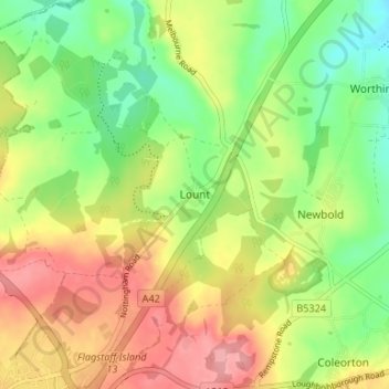
Name: Lount topographic map, elevation, terrain.
Average elevation: 118 m
Minimum elevation: 72 m
Maximum elevation: 169 m
Make a donation
Gear up for your next adventure:
As an Amazon Associate, this site earns from qualifying purchases at no extra cost to you.
Other topographic maps
Click on a map to view its topography, its elevation and its terrain.
Ashby-de-la-Zouch
United Kingdom > England > Leicestershire > North West Leicestershire
Average elevation: 132 m
Kelham Bridge Nature Reserve
United Kingdom > England > Leicestershire > North West Leicestershire > Ravenstone
Average elevation: 139 m
Castle Donington
United Kingdom > England > Leicestershire > North West Leicestershire > Hemington
Average elevation: 56 m
Swannington
United Kingdom > England > Leicestershire > North West Leicestershire > Coalville
Average elevation: 132 m
Make a donation
Gear up for your next adventure:
As an Amazon Associate, this site earns from qualifying purchases at no extra cost to you.
Lount Wood
United Kingdom > England > Leicestershire > North West Leicestershire > Lount
Average elevation: 131 m
Ibstock
United Kingdom > England > Leicestershire > North West Leicestershire
Average elevation: 134 m
Whitwick
United Kingdom > England > Leicestershire > North West Leicestershire
Average elevation: 152 m
Nailstone Colliery Railway
United Kingdom > England > Leicestershire > North West Leicestershire > Ibstock
Average elevation: 155 m
Make a donation
Gear up for your next adventure:
As an Amazon Associate, this site earns from qualifying purchases at no extra cost to you.
Breedon Cloud Wood
United Kingdom > England > Leicestershire > North West Leicestershire > Breedon on the Hill
Average elevation: 90 m
Swannymote Rock
United Kingdom > England > Leicestershire > North West Leicestershire > Coalville
Average elevation: 139 m
Willesley Woods
United Kingdom > England > Leicestershire > North West Leicestershire > Ashby-de-la-Zouch > Willesley
Average elevation: 108 m
Osgathorpe
United Kingdom > England > Leicestershire > North West Leicestershire
Average elevation: 96 m
Make a donation
Gear up for your next adventure:
As an Amazon Associate, this site earns from qualifying purchases at no extra cost to you.
Normanton Le Heath
United Kingdom > England > Leicestershire > North West Leicestershire
Average elevation: 123 m
Kegworth
United Kingdom > England > Leicestershire > North West Leicestershire > Kegworth
Average elevation: 49 m
Packington
United Kingdom > England > Leicestershire > North West Leicestershire
Average elevation: 119 m
Coleorton
United Kingdom > England > Leicestershire > North West Leicestershire
Average elevation: 130 m
Make a donation
Gear up for your next adventure:
As an Amazon Associate, this site earns from qualifying purchases at no extra cost to you.
Ashby de la Zouch Canal
United Kingdom > England > Leicestershire > North West Leicestershire > Moira
Average elevation: 100 m
Worthington
United Kingdom > England > Leicestershire > North West Leicestershire
Average elevation: 103 m
Isley cum Langley
United Kingdom > England > Leicestershire > North West Leicestershire > Isley Walton
Average elevation: 80 m
Make a donation
Gear up for your next adventure:
As an Amazon Associate, this site earns from qualifying purchases at no extra cost to you.
Appleby Magna
United Kingdom > England > Leicestershire > North West Leicestershire
Average elevation: 95 m
Cademan Wood
United Kingdom > England > Leicestershire > North West Leicestershire > Whitwick
Average elevation: 138 m
New Lount Nature Reserve
United Kingdom > England > Leicestershire > North West Leicestershire > Worthington
Average elevation: 120 m
Make a donation
Gear up for your next adventure:
As an Amazon Associate, this site earns from qualifying purchases at no extra cost to you.
Ashby de la Zouch Canal
United Kingdom > England > Leicestershire > North West Leicestershire > Oakthorpe
Average elevation: 97 m
Sence Valley Country Park
United Kingdom > England > Leicestershire > North West Leicestershire > Coalville > Heather
Average elevation: 131 m