
Sirdarya Province topographic map
Interactive map
Click on the map to display elevation.
About this map
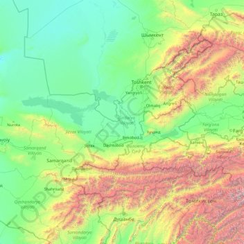
Name: Sirdarya Province topographic map, elevation, terrain.
Location: Sirdarya Province, Uzbekistan (37.90185 66.14266 43.10185 71.34266)
Average elevation: 1,233 m
Minimum elevation: 170 m
Maximum elevation: 7,325 m
Other topographic maps
Click on a map to view its topography, its elevation and its terrain.
Fergana City
Fergana City, Fergana Region, Uzbekistan
Average elevation: 587 m
Urgench
Uzbekistan > Xorazm Region > Urgench
Urgench, Xorazm Region, 220100, Uzbekistan
Average elevation: 100 m
Shayhontohur Tumani
Shayhontohur Tumani, Tashkent, 100000, Uzbekistan
Average elevation: 434 m
Yakkasaroy Tumani
Yakkasaroy Tumani, Tashkent, 100000, Uzbekistan
Average elevation: 692 m
Beshtut
Uzbekistan > Tashkent Region > Beshtut
Beshtut, Bostanlik district, Tashkent Region, Uzbekistan
Average elevation: 895 m
Olmaty
Uzbekistan > Qashqadaryo Region > Olmaty
Olmaty, Shakhrisabz District, Qashqadaryo Region, 181300, Uzbekistan
Average elevation: 1,588 m
Akmola
Uzbekistan > Tashkent Region > Yukorichirchik district
Akmola, Yukorichirchik district, Tashkent Region, Uzbekistan
Average elevation: 456 m