
Shayhontohur Tumani topographic map
Interactive map
Click on the map to display elevation.
About this map
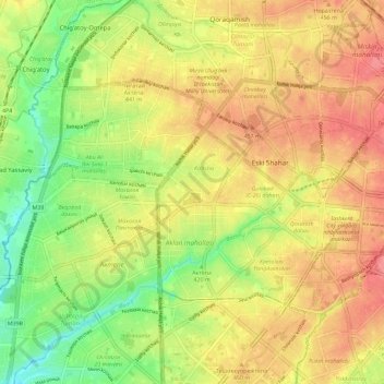
Name: Shayhontohur Tumani topographic map, elevation, terrain.
Location: Shayhontohur Tumani, Tashkent, 100000, Uzbekistan (41.29959 69.15986 41.35014 69.27491)
Average elevation: 434 m
Minimum elevation: 393 m
Maximum elevation: 467 m
Other topographic maps
Click on a map to view its topography, its elevation and its terrain.
Yakkasaroy Tumani
Yakkasaroy Tumani, Tashkent, 100000, Uzbekistan
Average elevation: 692 m