
Make a donation
Gear up for your next adventure:
As an Amazon Associate, this site earns from qualifying purchases at no extra cost to you.
Ankum topographic map
Click on the map to display elevation.
Make a donation
Gear up for your next adventure:
As an Amazon Associate, this site earns from qualifying purchases at no extra cost to you.
About this map
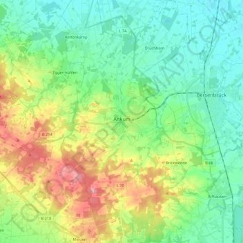
Name: Ankum topographic map, elevation, terrain.
Average elevation: 63 m
Minimum elevation: 26 m
Maximum elevation: 140 m
Make a donation
Gear up for your next adventure:
As an Amazon Associate, this site earns from qualifying purchases at no extra cost to you.
Other topographic maps
Click on a map to view its topography, its elevation and its terrain.
Make a donation
Gear up for your next adventure:
As an Amazon Associate, this site earns from qualifying purchases at no extra cost to you.
Bad Essen
Duitsland > Nedersaksen > Landkreis Osnabrück > Bad Essen > Bad Essen
Bad Essen ligt in het overgangsgebied tussen het Teutoburger Wald en de Noord-Duitse Laagvlakte. Het Wiehengebergte bedekt het zuidelijke deel van de gemeente, waar ook het hoogste punt ligt met 215 m hoogte bij de buurtschap Büscherheide. Het noordelijke deel is vrij vlak en ligt slechts op 50 m hoogte. De…
Average elevation: 85 m
Westerholte
Duitsland > Nedersaksen > Landkreis Osnabrück > Ankum > Westerholte
Average elevation: 92 m
Kloster Oesede
Duitsland > Nedersaksen > Landkreis Osnabrück > Georgsmarienhütte > Kloster Oesede
Average elevation: 125 m
Make a donation
Gear up for your next adventure:
As an Amazon Associate, this site earns from qualifying purchases at no extra cost to you.