
Thank you for supporting this site ❤️
Make a donation
Make a donation
Gear up for your next adventure:
As an Amazon Associate, this site earns from qualifying purchases at no extra cost to you.
Engter topographic map
Click on the map to display elevation.
Thank you for supporting this site ❤️
Make a donation
Make a donation
Gear up for your next adventure:
As an Amazon Associate, this site earns from qualifying purchases at no extra cost to you.
About this map
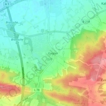
Name: Engter topographic map, elevation, terrain.
Location: Engter, Bramsche, Landkreis Osnabrück, Nedersaksen, Duitsland (52.36682 8.04214 52.40682 8.08214)
Average elevation: 87 m
Minimum elevation: 49 m
Maximum elevation: 158 m
Thank you for supporting this site ❤️
Make a donation
Make a donation
Gear up for your next adventure:
As an Amazon Associate, this site earns from qualifying purchases at no extra cost to you.