
Make a donation
Gear up for your next adventure:
As an Amazon Associate, this site earns from qualifying purchases at no extra cost to you.
Mohnenfluh topographic map
Click on the map to display elevation.
Make a donation
Gear up for your next adventure:
As an Amazon Associate, this site earns from qualifying purchases at no extra cost to you.
Mohnenfluh
Der Name „Mohn(-en)“ stehe möglicherweise im Zusammenhang mit dem Mond. Da sich in der Nähe auch Bergmähder befinden, kann auch eine Ableitung von Mahd/Mähen gegeben sein. Adelung nennt als Bedeutung für „Fluh“ („Fluhe“) in seinem Grammatisch-kritischen Wörterbuch der Hochdeutschen Mundart, als „ein nur im Oberdeutschen, besonders der Schweiz übliches Wort“: „eine Steinmasse, welche sich in einer beträchtlichen Breite erstrecket, ein Flötz, oft aber auch eine Steinmasse von beträchtlicher Höhe“ bzw. „eine Felsenwand, ein Fels; wo es bald Fluh, Fluhe, Flii, Fluc u. s. f. lautet“.
Make a donation
Gear up for your next adventure:
As an Amazon Associate, this site earns from qualifying purchases at no extra cost to you.
About this map
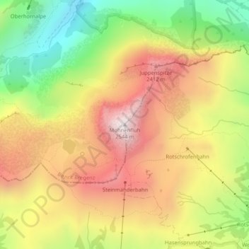
Name: Mohnenfluh topographic map, elevation, terrain.
Average elevation: 2,014 m
Minimum elevation: 1,463 m
Maximum elevation: 2,526 m
Make a donation
Gear up for your next adventure:
As an Amazon Associate, this site earns from qualifying purchases at no extra cost to you.
Other topographic maps
Click on a map to view its topography, its elevation and its terrain.
Körbersee
Österreich > Vorarlberg > Bezirk Bregenz > Gemeinde Schröcken > Schröcken
Der Körbersee befindet sich südwestlich des Hochtannbergpasses im österreichischen Bundesland Vorarlberg im Gemeindegebiet von Schröcken. Er liegt im Lechquellengebirge auf einer Höhe von 1654 m ü. A. und kann nur zu Fuß erreicht werden.
Average elevation: 1,654 m