
Nolanville topographic map
Interactive map
Click on the map to display elevation.
About this map
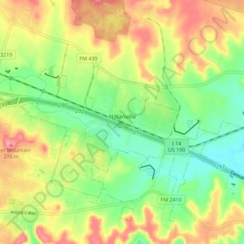
Name: Nolanville topographic map, elevation, terrain.
Location: Nolanville, Bell County, Texas, 76559, United States (31.05538 -97.64512 31.09896 -97.56599)
Average elevation: 231 m
Minimum elevation: 191 m
Maximum elevation: 277 m
Other topographic maps
Click on a map to view its topography, its elevation and its terrain.
Killeen
United States > Texas > Bell County
Killeen, Bell County, Texas, United States
Average elevation: 266 m
Zabcikville
United States > Texas > Bell County
Zabcikville, Bell County, Texas, United States
Average elevation: 149 m
Moffat
United States > Texas > Bell County
Moffat, Bell County, Texas, United States
Average elevation: 204 m
Youngsport
United States > Texas > Bell County
Youngsport, Bell County, Texas, United States
Average elevation: 226 m
Owl Creek
United States > Texas > Bell County
Owl Creek, Bell County, Texas, United States
Average elevation: 204 m
Red Ranger
United States > Texas > Bell County
Red Ranger, Bell County, Texas, United States
Average elevation: 139 m
Prairie Dell
United States > Texas > Bell County
Prairie Dell, Bell County, Texas, United States
Average elevation: 237 m
Ding Dong
United States > Texas > Bell County
Ding Dong, Bell County, Texas, United States
Average elevation: 241 m
Summers Mill
United States > Texas > Bell County
Summers Mill, Bell County, Texas, United States
Average elevation: 161 m
Union Grove
United States > Texas > Bell County
Union Grove, Bell County, Texas, United States
Average elevation: 218 m
Bland Mountain
United States > Texas > Bell County
Bland Mountain, Bell County, Texas, United States
Average elevation: 192 m
Airville
United States > Texas > Bell County
Airville, Bell County, Texas, United States
Average elevation: 161 m
Edgeworth
United States > Texas > Bell County
Edgeworth, Bell County, Texas, United States
Average elevation: 128 m
Heidenheimer
United States > Texas > Bell County
Heidenheimer, Bell County, Texas, 76533, United States
Average elevation: 162 m
Joe Lee
United States > Texas > Bell County
Joe Lee, Bell County, Texas, 76569, United States
Average elevation: 148 m
Oenaville
United States > Texas > Bell County
Oenaville, Bell County, Texas, United States
Average elevation: 168 m
Seaton
United States > Texas > Bell County
Seaton, Bell County, Texas, United States
Average elevation: 150 m
Vilas
United States > Texas > Bell County
Vilas, Bell County, Texas, United States
Average elevation: 146 m
Cyclone
United States > Texas > Bell County
Cyclone, Bell County, Texas, United States
Average elevation: 144 m
Belfalls
United States > Texas > Bell County
Belfalls, Bell County, Texas, United States
Average elevation: 169 m
Pendleton
United States > Texas > Bell County
Pendleton, Bell County, Texas, 76564, United States
Average elevation: 234 m
Little River-Academy
United States > Texas > Bell County
Little River-Academy, Bell County, Texas, 76554, United States
Average elevation: 153 m
Leedale
United States > Texas > Bell County
Leedale, Bell County, Texas, United States
Average elevation: 147 m
Maxdale
United States > Texas > Bell County
Maxdale, Bell County, Texas, United States
Average elevation: 247 m
Meeks
United States > Texas > Bell County
Meeks, Bell County, Texas, 76519, United States
Average elevation: 134 m
New Colony
United States > Texas > Bell County
New Colony, Bell County, Texas, United States
Average elevation: 134 m
Oscar
United States > Texas > Bell County
Oscar, Bell County, Texas, 76533, United States
Average elevation: 156 m
Ratibor
United States > Texas > Bell County
Ratibor, Bell County, Texas, United States
Average elevation: 157 m
Sparks
United States > Texas > Bell County
Sparks, Bell County, Texas, United States
Average elevation: 149 m
Stampede
United States > Texas > Bell County
Stampede, Bell County, Texas, 76557, United States
Average elevation: 210 m
White Hall
United States > Texas > Bell County
White Hall, Bell County, Texas, United States
Average elevation: 211 m
Rogers
United States > Texas > Bell County
Rogers, Bell County, Texas, United States
Average elevation: 159 m
Temple
United States > Texas > Bell County
Temple, Bell County, Texas, United States
Average elevation: 186 m
Lone Star
United States > Texas > Bell County > Killeen
Lone Star, Killeen, Bell County, Texas, 76543, United States
Average elevation: 250 m
Holland
United States > Texas > Bell County
Holland, Bell County, Texas, United States
Average elevation: 166 m
Belton Lake
United States > Texas > Bell County > Morgans Point Resort
Belton Lake, Morgans Point Resort, Bell County, Texas, United States
Average elevation: 216 m
Little River
United States > Texas > Bell County
Little River, Bell County, Texas, 76554, United States
Average elevation: 150 m
Belton
United States > Texas > Bell County
Belton, Bell County, Texas, United States
Average elevation: 179 m
Cedar Valley
United States > Texas > Bell County
Cedar Valley, Bell County, Texas, United States
Average elevation: 262 m
Lions Park
United States > Texas > Bell County > Temple
Lions Park, Temple, Bell County, Texas, United States
Average elevation: 161 m
Troy
United States > Texas > Bell County
Troy, Bell County, Texas, 76579, United States
Average elevation: 212 m
Morgans Point Resort
United States > Texas > Bell County > Morgans Point Resort > Morgans Point Resort
Morgans Point Resort, Bell County, Texas, United States
Average elevation: 201 m
Temple
United States > Texas > Bell County
Temple, Bell County, Texas, United States
Average elevation: 186 m
Killeen
United States > Texas > Bell County > Killeen
Killeen, Bell County, Texas, 76541, United States
Average elevation: 257 m
Morgans Point Resort
United States > Texas > Bell County
Morgans Point Resort, Bell County, Texas, United States
Average elevation: 201 m
Salado
United States > Texas > Bell County
Salado, Bell County, Texas, 76571, United States
Average elevation: 196 m
Harker Heights
United States > Texas > Bell County
Harker Heights, Bell County, Texas, 76548, United States
Average elevation: 235 m
Gober
United States > Texas > Bell County > Temple
Gober, Temple, Bell County, Texas, 76504, United States
Average elevation: 209 m