
Hempfield Township topographic map
Interactive map
Click on the map to display elevation.
About this map
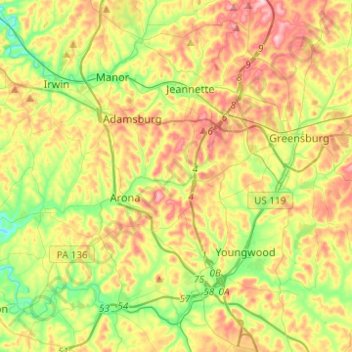
Name: Hempfield Township topographic map, elevation, terrain.
Average elevation: 340 m
Minimum elevation: 241 m
Maximum elevation: 464 m
Other topographic maps
Click on a map to view its topography, its elevation and its terrain.
Export
United States > Pennsylvania > Westmoreland County > Export
Export, Westmoreland County, Pennsylvania, 15632, United States
Average elevation: 342 m
Salina
United States > Pennsylvania > Westmoreland County > Bell Township
Salina, Bell Township, Westmoreland County, Pennsylvania, 15680, United States
Average elevation: 333 m
New Kensington
United States > Pennsylvania > Westmoreland County
New Kensington, Westmoreland County, Pennsylvania, 15068, United States
Average elevation: 287 m
Fort Allen
United States > Pennsylvania > Westmoreland County > Hempfield Township
Fort Allen, Hempfield Township, Westmoreland County, Pennsylvania, 15697, United States
Average elevation: 347 m
Lower Burrell
United States > Pennsylvania > Westmoreland County
Lower Burrell, Westmoreland County, Pennsylvania, United States
Average elevation: 296 m
Greensburg
United States > Pennsylvania > Westmoreland County
Greensburg, Westmoreland County, Pennsylvania, 15601, United States
Average elevation: 353 m
Laurel Mountain
United States > Pennsylvania > Westmoreland County
Laurel Mountain, Westmoreland County, Pennsylvania, 15655, United States
Average elevation: 476 m
Lynnwood-Pricedale
United States > Pennsylvania > Westmoreland County > Rostraver Township > Pricedale
Lynnwood-Pricedale, Pricedale, Rostraver Township, Westmoreland County, Pennsylvania, 15072, United States
Average elevation: 285 m
Trafford
United States > Pennsylvania > Westmoreland County
Trafford, Westmoreland County, Pennsylvania, United States
Average elevation: 294 m
Murrysville
United States > Pennsylvania > Westmoreland County
Murrysville, Westmoreland County, Pennsylvania, 15668, United States
Average elevation: 344 m
Southwest Greensburg
United States > Pennsylvania > Westmoreland County
Southwest Greensburg, Westmoreland County, Pennsylvania, United States
Average elevation: 331 m
Manor
United States > Pennsylvania > Westmoreland County
Manor, Westmoreland County, Pennsylvania, 15665, United States
Average elevation: 322 m
Loyalhanna
United States > Pennsylvania > Westmoreland County > Derry Township
Loyalhanna, Derry Township, Westmoreland County, Pennsylvania, 15661, United States
Average elevation: 331 m
Monessen
United States > Pennsylvania > Westmoreland County
Monessen, Westmoreland County, Pennsylvania, 15062, United States
Average elevation: 280 m
Penn Township
United States > Pennsylvania > Westmoreland County
Penn Township, Westmoreland County, Pennsylvania, United States
Average elevation: 346 m
Forbes Road
United States > Pennsylvania > Westmoreland County > Salem Township
Forbes Road, Salem Township, Westmoreland County, Pennsylvania, 15633, United States
Average elevation: 366 m
New Florence
United States > Pennsylvania > Westmoreland County
New Florence, Westmoreland County, Pennsylvania, United States
Average elevation: 346 m
Whites Hill
United States > Pennsylvania > Westmoreland County > Hempfield Township
Whites Hill, Hempfield Township, Westmoreland County, Pennsylvania, 15697, United States
Average elevation: 324 m
Ligonier
United States > Pennsylvania > Westmoreland County
Ligonier, Westmoreland County, Pennsylvania, United States
Average elevation: 379 m
Lawson Heights
United States > Pennsylvania > Westmoreland County > Unity Township > Lawson Heights
Lawson Heights, Unity Township, Westmoreland County, Pennsylvania, 15650, United States
Average elevation: 319 m
Washington Township
United States > Pennsylvania > Westmoreland County
Washington Township, Westmoreland County, Pennsylvania, 15613, United States
Average elevation: 358 m
North Huntingdon Township
United States > Pennsylvania > Westmoreland County
North Huntingdon Township, Westmoreland County, Pennsylvania, United States
Average elevation: 325 m
Jones Mills
United States > Pennsylvania > Westmoreland County > Donegal Township
Jones Mills, Donegal Township, Westmoreland County, Pennsylvania, 15646, United States
Average elevation: 523 m
Oak Grove
United States > Pennsylvania > Westmoreland County > Ligonier Township
Oak Grove, Ligonier Township, Westmoreland County, Pennsylvania, 15658, United States
Average elevation: 414 m
Acme
United States > Pennsylvania > Westmoreland County > Mount Pleasant Township
Acme, Mount Pleasant Township, Westmoreland County, Pennsylvania, 15610, United States
Average elevation: 585 m
Rostraver Township
United States > Pennsylvania > Westmoreland County
Rostraver Township, Westmoreland County, Pennsylvania, United States
Average elevation: 308 m
Scottdale
United States > Pennsylvania > Westmoreland County
Scottdale, Westmoreland County, Pennsylvania, 15683, United States
Average elevation: 337 m
Basforth Acres
United States > Pennsylvania > Westmoreland County > Hempfield Township
Basforth Acres, Hempfield Township, Westmoreland County, Pennsylvania, 15634, United States
Average elevation: 379 m
Smithton
United States > Pennsylvania > Westmoreland County
Smithton, Westmoreland County, Pennsylvania, United States
Average elevation: 288 m
Mount Pleasant Township
United States > Pennsylvania > Westmoreland County
Mount Pleasant Township, Westmoreland County, Pennsylvania, United States
Average elevation: 426 m
West Newton
United States > Pennsylvania > Westmoreland County
West Newton, Westmoreland County, Pennsylvania, United States
Average elevation: 283 m
Reagantown
United States > Pennsylvania > Westmoreland County > South Huntingdon Township
Reagantown, South Huntingdon Township, Westmoreland County, Pennsylvania, 15691, United States
Average elevation: 398 m
Hyde Park
United States > Pennsylvania > Westmoreland County
Hyde Park, Westmoreland County, Pennsylvania, 15641, United States
Average elevation: 282 m
Keystone State Park
United States > Pennsylvania > Westmoreland County > Derry Township
Keystone State Park, Derry Township, Westmoreland County, Pennsylvania, United States
Average elevation: 352 m
Salem Township
United States > Pennsylvania > Westmoreland County
Salem Township, Westmoreland County, Pennsylvania, United States
Average elevation: 356 m
Derry Township
United States > Pennsylvania > Westmoreland County
Derry Township, Westmoreland County, Pennsylvania, United States
Average elevation: 385 m
Cook Township
United States > Pennsylvania > Westmoreland County
Cook Township, Westmoreland County, Pennsylvania, United States
Average elevation: 537 m
Fellsburg
United States > Pennsylvania > Westmoreland County > Rostraver Township
Fellsburg, Rostraver Township, Westmoreland County, Pennsylvania, 15087, United States
Average elevation: 333 m
Latrobe
United States > Pennsylvania > Westmoreland County
Latrobe, Westmoreland County, Pennsylvania, United States
Average elevation: 317 m
Derry
United States > Pennsylvania > Westmoreland County
Derry, Westmoreland County, Pennsylvania, 15627, United States
Average elevation: 397 m
Jeannette
United States > Pennsylvania > Westmoreland County
Jeannette, Westmoreland County, Pennsylvania, 15644, United States
Average elevation: 347 m
Southwest
United States > Pennsylvania > Westmoreland County > Mount Pleasant Township
Southwest, Mount Pleasant Township, Westmoreland County, Pennsylvania, 15685, United States
Average elevation: 336 m
Conemaugh River
United States > Pennsylvania > Westmoreland County
Conemaugh River, Westmoreland County, Pennsylvania, 15906, United States
Average elevation: 445 m
Midway
United States > Pennsylvania > Westmoreland County > Hempfield Township > Midway
Midway, Hempfield Township, Westmoreland County, Pennsylvania, 15697, United States
Average elevation: 330 m
Stanton Heights
United States > Pennsylvania > Westmoreland County > New Stanton > Stanton Heights
Stanton Heights, New Stanton, Westmoreland County, Pennsylvania, 15639, United States
Average elevation: 327 m
New Stanton
United States > Pennsylvania > Westmoreland County > New Stanton
New Stanton, Westmoreland County, Pennsylvania, 15672, United States
Average elevation: 325 m
Paintersville
United States > Pennsylvania > Westmoreland County > New Stanton > Paintersville
Paintersville, New Stanton, Westmoreland County, Pennsylvania, 15672, United States
Average elevation: 324 m
East Huntingdon Township
United States > Pennsylvania > Westmoreland County > East Huntingdon Township
East Huntingdon Township, Westmoreland County, Pennsylvania, United States
Average elevation: 357 m
Youngstown
United States > Pennsylvania > Westmoreland County > Youngstown
Youngstown, Westmoreland County, Pennsylvania, 15696, United States
Average elevation: 352 m
Hopewell
United States > Pennsylvania > Westmoreland County > Donegal Township > Hopewell
Hopewell, Donegal Township, Westmoreland County, Pennsylvania, 15646, United States
Average elevation: 542 m