
Make a donation
Gear up for your next adventure:
As an Amazon Associate, this site earns from qualifying purchases at no extra cost to you.
New Florence topographic map
Click on the map to display elevation.
Make a donation
Gear up for your next adventure:
As an Amazon Associate, this site earns from qualifying purchases at no extra cost to you.
About this map
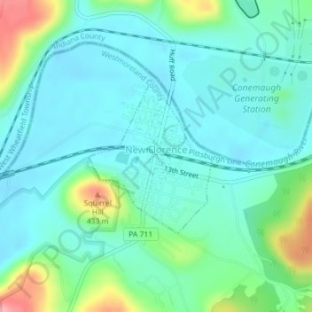
Name: New Florence topographic map, elevation, terrain.
Average elevation: 346 m
Minimum elevation: 317 m
Maximum elevation: 443 m
Make a donation
Gear up for your next adventure:
As an Amazon Associate, this site earns from qualifying purchases at no extra cost to you.
Other topographic maps
Click on a map to view its topography, its elevation and its terrain.
Whites Hill
United States > Pennsylvania > Westmoreland County > Hempfield Township
Average elevation: 324 m
Fort Allen
United States > Pennsylvania > Westmoreland County > Hempfield Township
Average elevation: 347 m
Alverton
United States > Pennsylvania > Westmoreland County > East Huntingdon Township
Average elevation: 361 m
Make a donation
Gear up for your next adventure:
As an Amazon Associate, this site earns from qualifying purchases at no extra cost to you.
Roaring Run Natural Area
United States > Pennsylvania > Westmoreland County > Donegal Township
Average elevation: 759 m
Oak Grove
United States > Pennsylvania > Westmoreland County > Ligonier Township
Average elevation: 414 m
Jones Mills
United States > Pennsylvania > Westmoreland County > Donegal Township
Average elevation: 523 m
Forbes Road
United States > Pennsylvania > Westmoreland County > Salem Township
Average elevation: 366 m
Make a donation
Gear up for your next adventure:
As an Amazon Associate, this site earns from qualifying purchases at no extra cost to you.
Alice
United States > Pennsylvania > Westmoreland County > Mount Pleasant Township
Average elevation: 450 m
Moween
United States > Pennsylvania > Westmoreland County > Loyalhanna Township
Average elevation: 319 m
Squirrel Hill
United States > Pennsylvania > Westmoreland County > Saint Clair Township
Average elevation: 354 m
Make a donation
Gear up for your next adventure:
As an Amazon Associate, this site earns from qualifying purchases at no extra cost to you.
Hopewell
United States > Pennsylvania > Westmoreland County > Donegal Township > Hopewell
Average elevation: 542 m
Stanton Heights
United States > Pennsylvania > Westmoreland County > New Stanton > Stanton Heights
Average elevation: 327 m
Paintersville
United States > Pennsylvania > Westmoreland County > New Stanton > Paintersville
Average elevation: 324 m
Midway
United States > Pennsylvania > Westmoreland County > Hempfield Township > Midway
Average elevation: 330 m
Make a donation
Gear up for your next adventure:
As an Amazon Associate, this site earns from qualifying purchases at no extra cost to you.
Fellsburg
United States > Pennsylvania > Westmoreland County > Rostraver Township
Average elevation: 333 m
Keystone State Park
United States > Pennsylvania > Westmoreland County > Derry Township
Average elevation: 352 m
Reagantown
United States > Pennsylvania > Westmoreland County > South Huntingdon Township
Average elevation: 398 m
Basforth Acres
United States > Pennsylvania > Westmoreland County > Hempfield Township
Average elevation: 379 m
Make a donation
Gear up for your next adventure:
As an Amazon Associate, this site earns from qualifying purchases at no extra cost to you.