
Valley County topographic map
Interactive map
Click on the map to display elevation.
About this map
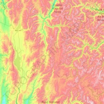
Name: Valley County topographic map, elevation, terrain.
Location: Valley County, Idaho, United States (44.15005 -116.21387 45.21800 -114.69413)
Average elevation: 1,964 m
Minimum elevation: 898 m
Maximum elevation: 3,127 m
Other topographic maps
Click on a map to view its topography, its elevation and its terrain.
Clearwater County
Clearwater County, Idaho, United States
Average elevation: 1,250 m
Cleveland
United States > Idaho > Franklin County
Cleveland, Franklin County, Idaho, 83283, United States
Average elevation: 1,560 m
Oldtown
United States > Idaho > Bonner County
Oldtown, Bonner County, Idaho, United States
Average elevation: 682 m
Rathdrum
United States > Idaho > Kootenai County
Rathdrum, Kootenai County, Idaho, United States
Average elevation: 701 m
Snake River
United States > Idaho > Washington County
Snake River, Washington County, Idaho, 83672, United States
Average elevation: 644 m