
Make a donation
Gear up for your next adventure:
As an Amazon Associate, this site earns from qualifying purchases at no extra cost to you.
Oldtown topographic map
Click on the map to display elevation.
Make a donation
Gear up for your next adventure:
As an Amazon Associate, this site earns from qualifying purchases at no extra cost to you.
Oldtown
Oldtown is located at 48°11′8″N 117°1′49″W / 48.18556°N 117.03028°W / 48.18556; -117.03028 (48.185623, -117.030158), at an elevation of 2,134 feet (650 meters).
Make a donation
Gear up for your next adventure:
As an Amazon Associate, this site earns from qualifying purchases at no extra cost to you.
About this map
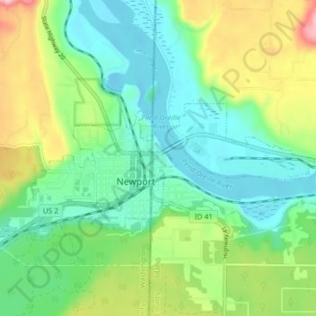
Name: Oldtown topographic map, elevation, terrain.
Location: Oldtown, Bonner County, Idaho, 83822, United States (48.17472 -117.03974 48.19177 -116.96573)
Average elevation: 682 m
Minimum elevation: 618 m
Maximum elevation: 824 m
Make a donation
Gear up for your next adventure:
As an Amazon Associate, this site earns from qualifying purchases at no extra cost to you.
Other topographic maps
Click on a map to view its topography, its elevation and its terrain.
Make a donation
Gear up for your next adventure:
As an Amazon Associate, this site earns from qualifying purchases at no extra cost to you.
Make a donation
Gear up for your next adventure:
As an Amazon Associate, this site earns from qualifying purchases at no extra cost to you.