
Shoshone County topographic map
Interactive map
Click on the map to display elevation.
About this map
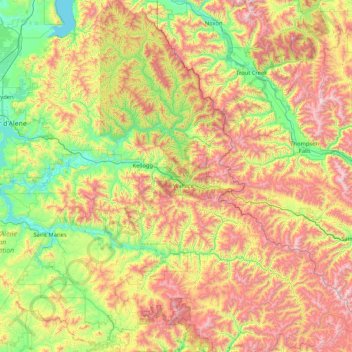
Name: Shoshone County topographic map, elevation, terrain.
Location: Shoshone County, Idaho, United States (46.93071 -116.32997 48.06772 -114.95879)
Average elevation: 1,204 m
Minimum elevation: 623 m
Maximum elevation: 2,280 m
Other topographic maps
Click on a map to view its topography, its elevation and its terrain.
Clearwater County
Clearwater County, Idaho, United States
Average elevation: 1,250 m
Cleveland
United States > Idaho > Franklin County
Cleveland, Franklin County, Idaho, 83283, United States
Average elevation: 1,560 m
Oldtown
United States > Idaho > Bonner County
Oldtown, Bonner County, Idaho, United States
Average elevation: 682 m
Rathdrum
United States > Idaho > Kootenai County
Rathdrum, Kootenai County, Idaho, United States
Average elevation: 701 m
Snake River
United States > Idaho > Washington County
Snake River, Washington County, Idaho, 83672, United States
Average elevation: 644 m