
Make a donation
Gear up for your next adventure:
As an Amazon Associate, this site earns from qualifying purchases at no extra cost to you.
Nanded District topographic map
Click on the map to display elevation.
Make a donation
Gear up for your next adventure:
As an Amazon Associate, this site earns from qualifying purchases at no extra cost to you.
Nanded District
Nanded is bounded on the north by Yavatmal district of the Vidarbha region, with Latur on south-west, Parbhani and Hingoli districts on the west. On the eastern side lies Adilabad, Nirmal, Nizamabad and Kamareddy districts of Telangana state, and on the south lies Bidar of Karnataka state. The area presents undulating topography with uneven hills, plateau, gentle slopes and valley planes.
Make a donation
Gear up for your next adventure:
As an Amazon Associate, this site earns from qualifying purchases at no extra cost to you.
About this map
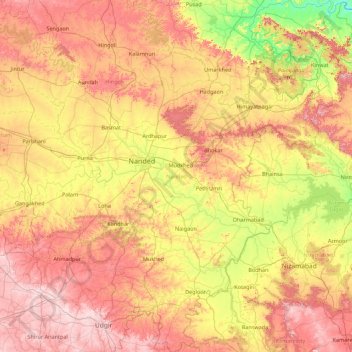
Name: Nanded District topographic map, elevation, terrain.
Location: Nanded District, Maharashtra, India (18.26281 76.93078 19.92503 78.36525)
Average elevation: 432 m
Minimum elevation: 229 m
Maximum elevation: 693 m
Make a donation
Gear up for your next adventure:
As an Amazon Associate, this site earns from qualifying purchases at no extra cost to you.
Other topographic maps
Click on a map to view its topography, its elevation and its terrain.
Make a donation
Gear up for your next adventure:
As an Amazon Associate, this site earns from qualifying purchases at no extra cost to you.
Chalisgaon
India > Maharashtra > Chalisgaon > Chalisgaon
Chalisgaon is located at 20°28′N 75°01′E / 20.47°N 75.02°E / 20.47; 75.02. It has an average elevation of 344 metres (1128 feet).
Average elevation: 345 m