
Thank you for supporting this site ❤️
Make a donation
Make a donation
Gear up for your next adventure:
As an Amazon Associate, this site earns from qualifying purchases at no extra cost to you.
Chalisgaon topographic map
Click on the map to display elevation.
Thank you for supporting this site ❤️
Make a donation
Make a donation
Gear up for your next adventure:
As an Amazon Associate, this site earns from qualifying purchases at no extra cost to you.
Chalisgaon
Chalisgaon is located at 20°28′N 75°01′E / 20.47°N 75.02°E / 20.47; 75.02. It has an average elevation of 344 metres (1128 feet).
Thank you for supporting this site ❤️
Make a donation
Make a donation
Gear up for your next adventure:
As an Amazon Associate, this site earns from qualifying purchases at no extra cost to you.
About this map
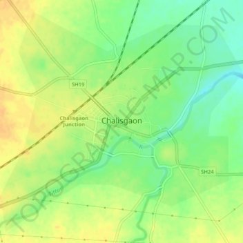
Name: Chalisgaon topographic map, elevation, terrain.
Location: Chalisgaon, Jalgaon, Maharashtra, India (20.44551 74.98695 20.47933 75.02684)
Average elevation: 345 m
Minimum elevation: 329 m
Maximum elevation: 357 m
Thank you for supporting this site ❤️
Make a donation
Make a donation
Gear up for your next adventure:
As an Amazon Associate, this site earns from qualifying purchases at no extra cost to you.