
Make a donation
Gear up for your next adventure:
As an Amazon Associate, this site earns from qualifying purchases at no extra cost to you.
Western Ghats topographic map
Click on the map to display elevation.
Make a donation
Gear up for your next adventure:
As an Amazon Associate, this site earns from qualifying purchases at no extra cost to you.
Western Ghats
Geologic evidence indicates that the mountains were formed during the break-up of the supercontinent of Gondwana. The mountains came along the west coast of India somewhere in the late Jurassic and early Cretaceous periods when India separated from the African continent. The mountains can be roughly divided into three parts: the northern section with an elevation ranging from 900–1,500 m (3,000–4,900 ft), the middle section starting from the south of Goa with a lower elevation of less than 900 m (3,000 ft), and the southern section where the altitude rises again. The Western Ghats have several peaks that rise above 2,000 m (6,600 ft), with Anamudi (2,695 m (8,842 ft)) being the highest peak. The average elevation is around 1,200 m (3,900 ft).
Make a donation
Gear up for your next adventure:
As an Amazon Associate, this site earns from qualifying purchases at no extra cost to you.
About this map
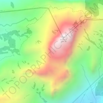
Name: Western Ghats topographic map, elevation, terrain.
Location: Western Ghats, Devikulam, Idukki, Kerala, 685614, India (10.16595 77.05795 10.16605 77.05805)
Average elevation: 2,225 m
Minimum elevation: 1,828 m
Maximum elevation: 2,685 m
Make a donation
Gear up for your next adventure:
As an Amazon Associate, this site earns from qualifying purchases at no extra cost to you.
Other topographic maps
Click on a map to view its topography, its elevation and its terrain.
Make a donation
Gear up for your next adventure:
As an Amazon Associate, this site earns from qualifying purchases at no extra cost to you.
Make a donation
Gear up for your next adventure:
As an Amazon Associate, this site earns from qualifying purchases at no extra cost to you.