
Thank you for supporting this site ❤️
Make a donation
Make a donation
Gear up for your next adventure:
As an Amazon Associate, this site earns from qualifying purchases at no extra cost to you.
Pothupara topographic map
Click on the map to display elevation.
Thank you for supporting this site ❤️
Make a donation
Make a donation
Gear up for your next adventure:
As an Amazon Associate, this site earns from qualifying purchases at no extra cost to you.
About this map
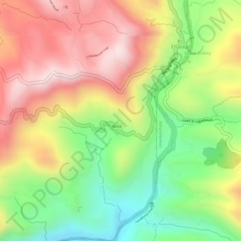
Name: Pothupara topographic map, elevation, terrain.
Location: Pothupara, Ellakkal, Devikulam, Idukki District, Kerala, India (9.97854 77.05397 10.00389 77.06446)
Average elevation: 769 m
Minimum elevation: 549 m
Maximum elevation: 966 m
Thank you for supporting this site ❤️
Make a donation
Make a donation
Gear up for your next adventure:
As an Amazon Associate, this site earns from qualifying purchases at no extra cost to you.