
Iowa County topographic map
Interactive map
Click on the map to display elevation.
About this map
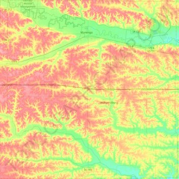
Name: Iowa County topographic map, elevation, terrain.
Location: Iowa County, Iowa, United States of America (41.50959 -92.30165 41.86295 -91.82700)
Average elevation: 249 m
Minimum elevation: 206 m
Maximum elevation: 288 m
Other topographic maps
Click on a map to view its topography, its elevation and its terrain.
Le Claire
United States of America > Iowa > Le Claire
Le Claire, Scott County, Iowa, United States of America
Average elevation: 201 m
Keystone
United States of America > Iowa > Keystone
Keystone, Benton County, Iowa, 52249, United States of America
Average elevation: 272 m
Woodbury County
United States of America > Iowa
Woodbury County, Iowa, United States of America
Average elevation: 376 m
Moorland
United States of America > Iowa > Moorland
Moorland, Webster County, Iowa, 50566, United States of America
Average elevation: 347 m
Ames
United States of America > Iowa > Ames
Ames, Story County, Iowa, United States of America
Average elevation: 292 m
Moville
United States of America > Iowa > Moville
Moville, Woodbury County, Iowa, United States of America
Average elevation: 361 m
Iowa City
United States of America > Iowa > Iowa City
Iowa City, Johnson County, Iowa, United States of America
Average elevation: 216 m