Geolocate

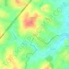
Si Racha Town Municipality topographic map

Click on the map to display elevation.

About this map

Name: Si Racha Town Municipality topographic map, elevation, terrain.

Location: Si Racha Town Municipality, Bang Phra, Si Racha District, Chon Buri Province, Thailand (13.15670 100.91528 13.18342 100.93256)

Average elevation: 16 m

Minimum elevation: -1 m

Maximum elevation: 123 m

Other topographic maps

Click on a map to view its topography, its elevation and its terrain.

Bang Phra

Thailand > Si Racha District

Average elevation: 23 m

Bo Win

Thailand > Si Racha District

Average elevation: 104 m

Gear up for your next adventure:

📚Travel Books Ireland - Best travel books for Irish exploration
🦺Outdoor Safety Vests - Increase visibility and safety
🗾Ireland Map Books - Top map books for exploring Ireland
🧂Electrolyte Tablets - Stay hydrated during strenuous mountain climbs
🪢Paracord & Ropes - Strong ropes for camping and gear

As an Amazon Associate, this site earns from qualifying purchases at no extra cost to you.