Geolocate

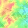
Bulverde topographic map

Click on the map to display elevation.

About this map
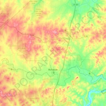
Name: Bulverde topographic map, elevation, terrain.

Location: Bulverde, Comal County, Texas, United States (29.71563 -98.52530 29.83061 -98.31001)

Average elevation: 364 m

Minimum elevation: 267 m

Maximum elevation: 468 m

Other topographic maps

Click on a map to view its topography, its elevation and its terrain.
Canyon Lake

United States > Texas > Comal County

Average elevation: 296 m

Gruene

United States > Texas > Comal County > New Braunfels

Average elevation: 210 m

Thorn Hill

United States > Texas > Comal County > New Braunfels

Average elevation: 213 m

Sattler

United States > Texas > Comal County

Average elevation: 265 m

Startzville

United States > Texas > Comal County

Average elevation: 333 m

Anhalt

United States > Texas > Comal County > Bulverde

Average elevation: 397 m

Fischer

United States > Texas > Comal County

Average elevation: 363 m

Canyon Lake

United States > Texas > Comal County

Average elevation: 296 m

Gruene

United States > Texas > Comal County > New Braunfels

Average elevation: 210 m

Preiss Heights

United States > Texas > Comal County

Average elevation: 214 m

Startzville

United States > Texas > Comal County

Average elevation: 333 m

Canyon Springs

United States > Texas > Comal County

Average elevation: 310 m

Gear up for your next adventure:

🧭Hiking Compasses - Reliable compasses for navigation off‑trail
🎧Wireless Earbuds - Music on the move
⌚Smart Watches for Hiking - Track performance on trails
📚Travel Books Ireland - Best travel books for Irish exploration
📍Handheld GPS Devices - Accurate GPS units for mapping and navigation

As an Amazon Associate, this site earns from qualifying purchases at no extra cost to you.