
Make a donation
Gear up for your next adventure:
As an Amazon Associate, this site earns from qualifying purchases at no extra cost to you.
Borchen topographic map
Click on the map to display elevation.
Make a donation
Gear up for your next adventure:
As an Amazon Associate, this site earns from qualifying purchases at no extra cost to you.
Borchen
Die als „große Landgemeinde“ klassifizierte Gemeinde liegt auf einer Höhe zwischen 125 m ü. NN (im Almetal) und 334 m ü. NN (östlich von Dörenhagen) und bedeckt eine Fläche von 77,13 km². Den größten Flächenanteil nehmen Wald- und Landwirtschaftsfläche mit zusammen ca. 87,2 % ein, Siedlungs- und Verkehrsfläche bedecken weitere rund 11,2 %. Die Ost-West-Ausdehnung beträgt etwa 13 km, die Nord-Süd-Ausdehnung etwa 10 km.
Make a donation
Gear up for your next adventure:
As an Amazon Associate, this site earns from qualifying purchases at no extra cost to you.
About this map
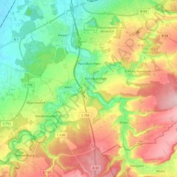
Name: Borchen topographic map, elevation, terrain.
Average elevation: 198 m
Minimum elevation: 105 m
Maximum elevation: 322 m
Make a donation
Gear up for your next adventure:
As an Amazon Associate, this site earns from qualifying purchases at no extra cost to you.
Other topographic maps
Click on a map to view its topography, its elevation and its terrain.
Bad Lippspringe
Deutschland > Nordrhein-Westfalen > Kreis Paderborn > Bad Lippspringe > Bad Lippspringe
Average elevation: 162 m
Aabachtalsperre
Deutschland > Nordrhein-Westfalen > Kreis Paderborn > Bad Wünnenberg
Die Aabachtalsperre liegt im Kreis Paderborn am Rand der Briloner Höhen zwischen Bad Wünnenberg im Nordwesten und Marsberg im Südosten. Das 27,2 km² große Einzugsgebiet der Talsperre erstreckt sich im Wesentlichen nach Südosten durch das Sintfeld und wird flankiert durch den „Fürstenberger Wald“ im…
Average elevation: 381 m
Make a donation
Gear up for your next adventure:
As an Amazon Associate, this site earns from qualifying purchases at no extra cost to you.
Ringelstein
Deutschland > Nordrhein-Westfalen > Kreis Paderborn > Büren > Harth
Average elevation: 334 m
Make a donation
Gear up for your next adventure:
As an Amazon Associate, this site earns from qualifying purchases at no extra cost to you.
Borchen
Deutschland > Nordrhein-Westfalen > Kreis Paderborn > Borchen > Borchen
Average elevation: 182 m
Habichtsee
Deutschland > Nordrhein-Westfalen > Kreis Paderborn > Paderborn > Sennelager
Average elevation: 112 m
Make a donation
Gear up for your next adventure:
As an Amazon Associate, this site earns from qualifying purchases at no extra cost to you.
Wewelsburg
Deutschland > Nordrhein-Westfalen > Kreis Paderborn > Büren
Das Dorf Wewelsburg liegt am Westrand der Paderborner Hochfläche, auf der Brenkener Bergplatte, oberhalb des tief eingeschnittenen Almetales, das die Grenze zum Hellwegraum darstellt. Die Gemarkung Wewelsburg umfasst Höhenbereiche von 163 m ü. NN im Almetal bis 340 m ü. NN an der L 754.
Average elevation: 222 m
Make a donation
Gear up for your next adventure:
As an Amazon Associate, this site earns from qualifying purchases at no extra cost to you.
Siedlung Forst
Deutschland > Nordrhein-Westfalen > Kreis Paderborn > Schwaney
Average elevation: 323 m
Barkhausen
Deutschland > Nordrhein-Westfalen > Kreis Paderborn > Paderborn > Wewer
Average elevation: 139 m
Make a donation
Gear up for your next adventure:
As an Amazon Associate, this site earns from qualifying purchases at no extra cost to you.
Make a donation
Gear up for your next adventure:
As an Amazon Associate, this site earns from qualifying purchases at no extra cost to you.
Mantinghausen
Deutschland > Nordrhein-Westfalen > Kreis Paderborn > Salzkotten
Average elevation: 84 m
Make a donation
Gear up for your next adventure:
As an Amazon Associate, this site earns from qualifying purchases at no extra cost to you.
Tallesee Mittelsee
Deutschland > Nordrhein-Westfalen > Kreis Paderborn > Paderborn
Average elevation: 118 m
Nesthauser See
Deutschland > Nordrhein-Westfalen > Kreis Paderborn > Paderborn > Sande
Average elevation: 101 m
Make a donation
Gear up for your next adventure:
As an Amazon Associate, this site earns from qualifying purchases at no extra cost to you.
Herbram
Deutschland > Nordrhein-Westfalen > Kreis Paderborn > Lichtenau > Herbram
Average elevation: 317 m
Asseln
Deutschland > Nordrhein-Westfalen > Kreis Paderborn > Lichtenau > Asseln
Average elevation: 335 m
Schloß Hamborn
Deutschland > Nordrhein-Westfalen > Kreis Paderborn > Borchen > Schloss Hamborn
Average elevation: 214 m
Make a donation
Gear up for your next adventure:
As an Amazon Associate, this site earns from qualifying purchases at no extra cost to you.
Herbram-Wald
Deutschland > Nordrhein-Westfalen > Kreis Paderborn
Herbram-Wald gehört wie Ostwestfalen-Lippe insgesamt zum ozeanischen Klimabereich Nordwestdeutschlands, dem es geringe Temperaturgegensätze und milde Winter verdankt. Allerdings sind schon kontinentale Einflüsse wirksam. So liegt die Temperatur im Sommer höher und die Nächte sind kühler als in größerer…
Average elevation: 333 m
Holsen
Deutschland > Nordrhein-Westfalen > Kreis Paderborn > Salzkotten > Holsen
Average elevation: 87 m