
Make a donation
Gear up for your next adventure:
As an Amazon Associate, this site earns from qualifying purchases at no extra cost to you.
Siedlung Forst topographic map
Click on the map to display elevation.
Make a donation
Gear up for your next adventure:
As an Amazon Associate, this site earns from qualifying purchases at no extra cost to you.
About this map
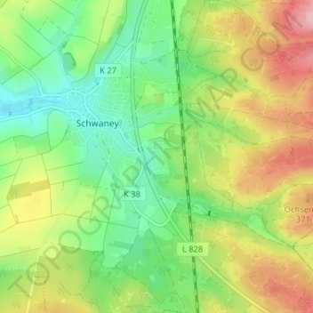
Name: Siedlung Forst topographic map, elevation, terrain.
Average elevation: 323 m
Minimum elevation: 253 m
Maximum elevation: 427 m
Make a donation
Gear up for your next adventure:
As an Amazon Associate, this site earns from qualifying purchases at no extra cost to you.
Other topographic maps
Click on a map to view its topography, its elevation and its terrain.
Schwaney
Deutschland > Nordrhein-Westfalen > Kreis Paderborn > Schwaney
Durch den Höhenunterschied zum Umland ist das Klima spürbar rauer. Bedingt durch die Hanglage an der Egge, kommt es in Schwaney häufig zu ergiebigem Steigungsregen.
Average elevation: 330 m