
Creek County topographic map
Interactive map
Click on the map to display elevation.
About this map
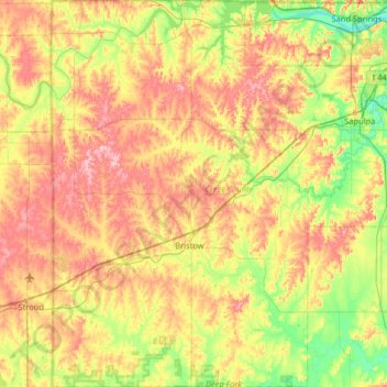
Name: Creek County topographic map, elevation, terrain.
Location: Creek County, Oklahoma, United States (35.63881 -96.62312 36.16438 -96.02863)
Average elevation: 255 m
Minimum elevation: 188 m
Maximum elevation: 338 m
Other topographic maps
Click on a map to view its topography, its elevation and its terrain.
Oilton
United States > Oklahoma > Creek County
Oilton, Creek County, Oklahoma, 74052, United States
Average elevation: 245 m
May
United States > Oklahoma > Harper County
May, Harper County, Oklahoma, United States
Average elevation: 626 m
Atoka County
United States > Oklahoma > Atoka County
Atoka County, Oklahoma, United States
Average elevation: 207 m
Woodward County
United States > Oklahoma > Woodward County
Woodward County, Oklahoma, United States
Average elevation: 575 m
Ardmore
United States > Oklahoma > Carter County > Ardmore
Ardmore, Carter County, Oklahoma, United States
Average elevation: 258 m