
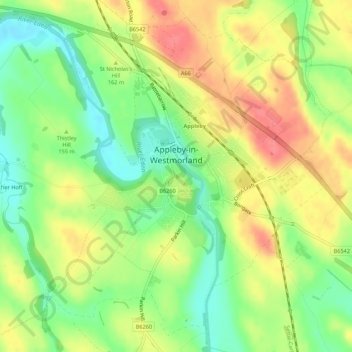
Appleby-in-Westmorland topographic map
Interactive map
Click on the map to display elevation.
About this map
Name: Appleby-in-Westmorland topographic map, elevation, terrain.
Average elevation: 155 m
Minimum elevation: 120 m
Maximum elevation: 192 m
Other topographic maps
Click on a map to view its topography, its elevation and its terrain.
High Cup Nick
United Kingdom > England > Westmorland and Furness > Murton
The Pennine Way skirts the valley on its northern side by a traditional route known as Narrow Gate as it runs from Forest in Teesdale west via Cauldron Snout and Maize Beck to Dufton. This national trail briefly splits into two separate routes on either bank of Maize Beck; it is the southerly of the two which…
Average elevation: 601 m
Alston
United Kingdom > England > Westmorland and Furness
Alston is a town in Westmorland and Furness, Cumbria, England, within the civil parish of Alston Moor on the River South Tyne. It shares the title of the 'highest market town in England', at about 1,000 feet (300 m) above sea level, with Buxton, Derbyshire. Despite its altitude, the town is easily accessible…
Average elevation: 404 m
Toddygill Plantation
United Kingdom > England > Westmorland and Furness > Warcop
Average elevation: 172 m