
Milwaukie topographic map
Interactive map
Click on the map to display elevation.
About this map
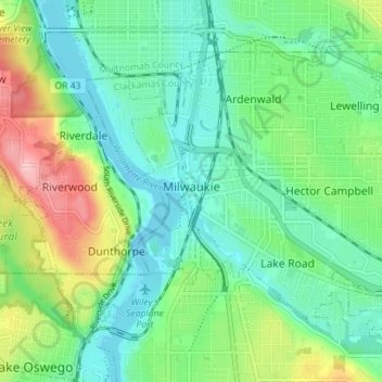
Name: Milwaukie topographic map, elevation, terrain.
Location: Milwaukie, Clackamas County, Oregon, 97222, United States (45.42469 -122.65225 45.46222 -122.58175)
Average elevation: 49 m
Minimum elevation: -7 m
Maximum elevation: 167 m
Other topographic maps
Click on a map to view its topography, its elevation and its terrain.
Oregon City
United States > Oregon > Clackamas County
Oregon City, Clackamas County, Oregon, 97045, United States
Average elevation: 99 m
Lake Oswego
United States > Oregon > Clackamas County
Lake Oswego, Clackamas County, Oregon, United States
Average elevation: 87 m
West Linn
United States > Oregon > Clackamas County
West Linn, Clackamas County, Oregon, 97068, United States
Average elevation: 74 m
Estacada
United States > Oregon > Clackamas County
Estacada, Clackamas County, Oregon, 97023, United States
Average elevation: 176 m
Wemme
United States > Oregon > Clackamas County > Welches
Wemme, Welches, Clackamas County, Oregon, 97067, United States
Average elevation: 494 m
Glen Avon
United States > Oregon > Clackamas County
Glen Avon, Clackamas County, Oregon, United States
Average elevation: 296 m
Damascus
United States > Oregon > Clackamas County
Damascus, Clackamas County, Oregon, 97089, United States
Average elevation: 144 m
Johnson City
United States > Oregon > Clackamas County
Johnson City, Clackamas County, Oregon, United States
Average elevation: 50 m
Logan
United States > Oregon > Clackamas County
Logan, Clackamas County, Oregon, United States
Average elevation: 131 m
Canby
United States > Oregon > Clackamas County
Canby, Clackamas County, Oregon, 97013, United States
Average elevation: 40 m
Mulino
United States > Oregon > Clackamas County
Mulino, Clackamas County, Oregon, 97042, United States
Average elevation: 100 m
Stafford
United States > Oregon > Clackamas County
Stafford, Clackamas County, Oregon, 97034, United States
Average elevation: 86 m
Viola
United States > Oregon > Clackamas County
Viola, Clackamas County, Oregon, United States
Average elevation: 172 m
Willamette Falls
United States > Oregon > Clackamas County > Oregon City
Willamette Falls, Oregon City, Clackamas County, Oregon, 97068, United States
Average elevation: 90 m
Welches
United States > Oregon > Clackamas County
Welches, Clackamas County, Oregon, 97067, United States
Average elevation: 526 m
Zigzag
United States > Oregon > Clackamas County
Zigzag, Clackamas County, Oregon, 97067, United States
Average elevation: 546 m
Devil's Peak
United States > Oregon > Clackamas County
Devil's Peak, Clackamas County, Oregon, United States
Average elevation: 1,205 m
Government Camp
United States > Oregon > Clackamas County
Government Camp, Clackamas County, Oregon, 97028, United States
Average elevation: 1,238 m
Molalla
United States > Oregon > Clackamas County
Molalla, Clackamas County, Oregon, 97038, United States
Average elevation: 113 m
Ramona Falls
United States > Oregon > Clackamas County
Ramona Falls, Clackamas County, Oregon, United States
Average elevation: 1,191 m
Damascus
United States > Oregon > Clackamas County
Damascus, Clackamas County, Oregon, 97089, United States
Average elevation: 149 m
Eagle Creek
United States > Oregon > Clackamas County
Eagle Creek, Clackamas County, Oregon, 97022, United States
Average elevation: 120 m
Gladstone
United States > Oregon > Clackamas County
Gladstone, Clackamas County, Oregon, 97027, United States
Average elevation: 41 m
Sherwood Forest Tot Lot
United States > Oregon > Clackamas County > Gladstone
Sherwood Forest Tot Lot, Gladstone, Clackamas County, Oregon, United States
Average elevation: 64 m
Redland
United States > Oregon > Clackamas County
Redland, Clackamas County, Oregon, United States
Average elevation: 122 m
Rivergrove
United States > Oregon > Clackamas County
Rivergrove, Clackamas County, Oregon, United States
Average elevation: 53 m
Cedar Island
United States > Oregon > Clackamas County > West Linn
Cedar Island, West Linn, Clackamas County, Oregon, United States
Average elevation: 38 m
North Highland
United States > Oregon > Clackamas County
North Highland, Clackamas County, Oregon, United States
Average elevation: 338 m
Barton
United States > Oregon > Clackamas County
Barton, Clackamas County, Oregon, United States
Average elevation: 106 m
Jean
United States > Oregon > Clackamas County > Lake Oswego
Jean, Lake Oswego, Clackamas County, Oregon, 97035, United States
Average elevation: 53 m
Oak Creek
United States > Oregon > Clackamas County > Lake Oswego
Oak Creek, Lake Oswego, Clackamas County, Oregon, United States
Average elevation: 123 m
Beavercreek
United States > Oregon > Clackamas County
Beavercreek, Clackamas County, Oregon, 97004, United States
Average elevation: 172 m
Ripplebrook
United States > Oregon > Clackamas County
Ripplebrook, Clackamas County, Oregon, United States
Average elevation: 568 m
Willamette
United States > Oregon > Clackamas County > West Linn
Willamette, West Linn, Clackamas County, Oregon, United States
Average elevation: 105 m
Sandy
United States > Oregon > Clackamas County
Sandy, Clackamas County, Oregon, 97055, United States
Average elevation: 247 m
Happy Valley
United States > Oregon > Clackamas County
Happy Valley, Clackamas County, Oregon, 97086, United States
Average elevation: 138 m
Boring
United States > Oregon > Clackamas County
Boring, Clackamas County, Oregon, 97009, United States
Average elevation: 183 m
Wilsonville
United States > Oregon > Clackamas County
Wilsonville, Clackamas County, Oregon, 97070, United States
Average elevation: 60 m
Fernwood
United States > Oregon > Clackamas County > Fernwood
Fernwood, Clackamas County, Oregon, United States
Average elevation: 317 m
Wilhoit Springs County Park
United States > Oregon > Clackamas County > Wilhoit
Wilhoit Springs County Park, Wilhoit, Clackamas County, Oregon, United States
Average elevation: 315 m
Colton
United States > Oregon > Clackamas County
Colton, Clackamas County, Oregon, 97017, United States
Average elevation: 228 m
Trillium Lake
United States > Oregon > Clackamas County
Trillium Lake, Clackamas County, Oregon, United States
Average elevation: 1,174 m
Barlow
United States > Oregon > Clackamas County
Barlow, Clackamas County, Oregon, United States
Average elevation: 31 m
The Villages at Mount Hood
United States > Oregon > Clackamas County > Welches
The Villages at Mount Hood, Welches, Clackamas County, Oregon, United States
Average elevation: 808 m