
Make a donation
Gear up for your next adventure:
As an Amazon Associate, this site earns from qualifying purchases at no extra cost to you.
Wilsonville topographic map
Click on the map to display elevation.
Make a donation
Gear up for your next adventure:
As an Amazon Associate, this site earns from qualifying purchases at no extra cost to you.
Wilsonville
Wilsonville is located on the southern edge of the Portland metropolitan area sitting at an elevation of 154 feet (47 m) above sea level. Primarily in the southwestern part of Clackamas County, the northern section is in Washington County. It is located on the north side of the Willamette River around where Alphonse Boone established the Boones Ferry. Neighboring cities are Tualatin on the north, Sherwood to the northwest, and Canby and Aurora to the southeast. Newberg in Yamhill County is approximately 14 miles west along Wilsonville Road. The Willamette separates the majority of the city from Charbonneau, a planned community and neighborhood within the city limits, on the south.
Make a donation
Gear up for your next adventure:
As an Amazon Associate, this site earns from qualifying purchases at no extra cost to you.
About this map
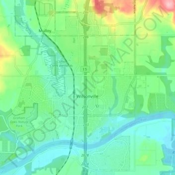
Name: Wilsonville topographic map, elevation, terrain.
Average elevation: 60 m
Minimum elevation: 18 m
Maximum elevation: 181 m
Make a donation
Gear up for your next adventure:
As an Amazon Associate, this site earns from qualifying purchases at no extra cost to you.
Other topographic maps
Click on a map to view its topography, its elevation and its terrain.
Make a donation
Gear up for your next adventure:
As an Amazon Associate, this site earns from qualifying purchases at no extra cost to you.
Make a donation
Gear up for your next adventure:
As an Amazon Associate, this site earns from qualifying purchases at no extra cost to you.
Make a donation
Gear up for your next adventure:
As an Amazon Associate, this site earns from qualifying purchases at no extra cost to you.
Make a donation
Gear up for your next adventure:
As an Amazon Associate, this site earns from qualifying purchases at no extra cost to you.
Make a donation
Gear up for your next adventure:
As an Amazon Associate, this site earns from qualifying purchases at no extra cost to you.
Wilhoit Springs County Park
United States > Oregon > Clackamas County > Wilhoit
Average elevation: 315 m
Make a donation
Gear up for your next adventure:
As an Amazon Associate, this site earns from qualifying purchases at no extra cost to you.