Geolocate

东山镇 topographic map

Interactive map

Click on the map to display elevation.

About this map

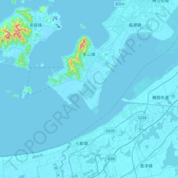
Name: 东山镇 topographic map, elevation, terrain.

Location: 东山镇, 吴中区, 苏州市, 江苏省, 中国 (30.92855 120.18482 31.13679 120.50577)

Average elevation: 6 m

Minimum elevation: -26 m

Maximum elevation: 309 m

Other topographic maps

Click on a map to view its topography, its elevation and its terrain.

木渎镇

中国 > 江苏省 > 吴中区

木渎镇, 吴中区, 苏州市, 江苏省, 215101, 中国

Average elevation: 18 m

越溪街道

中国 > 江苏省 > 吴中区

越溪街道, 吴中区, 苏州市, 江苏省, 中国

Average elevation: 15 m

石湖景区

中国 > 江苏省 > 吴中区

石湖景区, 吴中区, 苏州市, 江苏省, 中国

Average elevation: 8 m

甪直镇

中国 > 江苏省 > 吴中区

甪直镇, 吴中区, 苏州市, 江苏省, 中国

Average elevation: 2 m

光福镇

中国 > 江苏省 > 吴中区 > 光福镇

光福镇, 吴中区, 苏州市, 江苏省, 中国

Average elevation: 9 m